

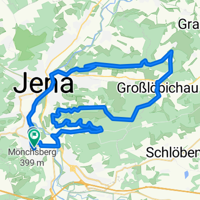
Rittergut Positz
A cycling route starting in Jena, Free State of Thuringia, Germany.
Overview
About this route
Sehr schöne durchwachsene Tour, nach 22 km höchster Anstieg, dann alles entspannend
- -:--
- Duration
- 69.6 km
- Distance
- 413 m
- Ascent
- 413 m
- Descent
- ---
- Avg. speed
- ---
- Avg. speed
Route quality
Waytypes & surfaces along the route
Waytypes
Quiet road
19.8 km
(28 %)
Track
16 km
(23 %)
Surfaces
Paved
43.9 km
(63 %)
Unpaved
16.6 km
(24 %)
Asphalt
41.5 km
(60 %)
Gravel
12.8 km
(18 %)
Route highlights
Points of interest along the route

Photo after 24.5 km
Welkenteich, zur Rast

Accommodation after 26.6 km
Waldfrieden

Accommodation after 30.6 km
Rittergut-Positz

Photo after 51.9 km
Blick zur Leuchtenburg
Continue with Bikemap
Use, edit, or download this cycling route
You would like to ride Rittergut Positz or customize it for your own trip? Here is what you can do with this Bikemap route:
Free features
- Save this route as favorite or in collections
- Copy & plan your own version of this route
- Sync your route with Garmin or Wahoo
Premium features
Free trial for 3 days, or one-time payment. More about Bikemap Premium.
- Navigate this route on iOS & Android
- Export a GPX / KML file of this route
- Create your custom printout (try it for free)
- Download this route for offline navigation
Discover more Premium features.
Get Bikemap PremiumFrom our community
Other popular routes starting in Jena
 : Halbtagestour mit Kindern
- Distance
- 29.6 km
- Ascent
- 185 m
- Descent
- 201 m
- Location
- Jena, Free State of Thuringia, Germany
 Trainingsrunde
- Distance
- 34.9 km
- Ascent
- 559 m
- Descent
- 558 m
- Location
- Jena, Free State of Thuringia, Germany
 Tour um Jena, Jägerberg, Isserstedt , Magdala
- Distance
- 37.5 km
- Ascent
- 346 m
- Descent
- 344 m
- Location
- Jena, Free State of Thuringia, Germany
 2. Rad n Roll MTB Marathon
- Distance
- 28.6 km
- Ascent
- 607 m
- Descent
- 494 m
- Location
- Jena, Free State of Thuringia, Germany
 Forst/Ammerbach
- Distance
- 14.2 km
- Ascent
- 291 m
- Descent
- 291 m
- Location
- Jena, Free State of Thuringia, Germany
 Jena - Leuchtenburg/St. Ganloff
- Distance
- 91.1 km
- Ascent
- 585 m
- Descent
- 585 m
- Location
- Jena, Free State of Thuringia, Germany
 Klein aber Fein
- Distance
- 32.9 km
- Ascent
- 335 m
- Descent
- 293 m
- Location
- Jena, Free State of Thuringia, Germany
 Jena - Stausee Hohenfelden - Kunitzburg - Jena CLONED FROM ROUTE 1736593
- Distance
- 109.9 km
- Ascent
- 623 m
- Descent
- 623 m
- Location
- Jena, Free State of Thuringia, Germany
Open it in the app