
La Canda, Christy & Rancho
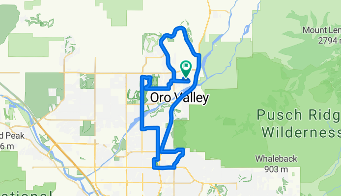
A cycling route starting in Oro Valley, Arizona, United States of America.
Overview
About this route
- -:--
- Duration
- 49.8 km
- Distance
- 379 m
- Ascent
- 379 m
- Descent
- ---
- Avg. speed
- ---
- Avg. speed
Continue with Bikemap
Use, edit, or download this cycling route
You would like to ride La Canda, Christy & Rancho or customize it for your own trip? Here is what you can do with this Bikemap route:
Free features
- Save this route as favorite or in collections
- Copy & plan your own version of this route
- Sync your route with Garmin or Wahoo
Premium features
Free trial for 3 days, or one-time payment. More about Bikemap Premium.
- Navigate this route on iOS & Android
- Export a GPX / KML file of this route
- Create your custom printout (try it for free)
- Download this route for offline navigation
Discover more Premium features.
Get Bikemap PremiumFrom our community
Other popular routes starting in Oro Valley
 Home loop
- Distance
- 29.5 km
- Ascent
- 192 m
- Descent
- 180 m
- Location
- Oro Valley, Arizona, United States of America
 Alyssa's Loop
- Distance
- 17.4 km
- Ascent
- 140 m
- Descent
- 142 m
- Location
- Oro Valley, Arizona, United States of America
 Rancho Vistoso Blvd Round Trip from Safeway
- Distance
- 24.2 km
- Ascent
- 199 m
- Descent
- 199 m
- Location
- Oro Valley, Arizona, United States of America
 Tucson to Marana
- Distance
- 25 km
- Ascent
- 716 m
- Descent
- 865 m
- Location
- Oro Valley, Arizona, United States of America
 N Vistoso Village Dr, Oro Valley to 3855 E Speedway Blvd, Tucson
- Distance
- 44.4 km
- Ascent
- 167 m
- Descent
- 271 m
- Location
- Oro Valley, Arizona, United States of America
 9501–9599 N Rancho Feliz Dr, Oro Valley to 11335 N Eagle Landing Pl, Oro Valley
- Distance
- 36.3 km
- Ascent
- 3,278 m
- Descent
- 3,181 m
- Location
- Oro Valley, Arizona, United States of America
 The Loop and Canada Del Oro Bike Trails
- Distance
- 54.1 km
- Ascent
- 201 m
- Descent
- 143 m
- Location
- Oro Valley, Arizona, United States of America
 OroValley - CC
- Distance
- 732.3 km
- Ascent
- 1,332 m
- Descent
- 2,063 m
- Location
- Oro Valley, Arizona, United States of America
Open it in the app