
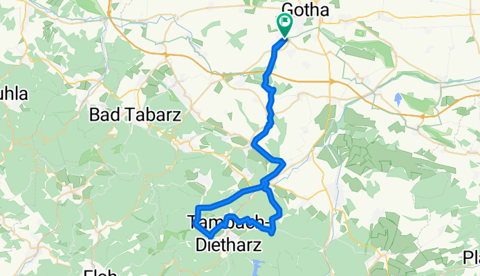
gth-boxberg-gospiteroda-georgenthal-neues haus-tambach dietharz-steigerhaus-wechmarer huette-georgenthal-gospiteroda-boxberg-gth
A cycling route starting in Gotha, Free State of Thuringia, Germany.
Overview
About this route
- -:--
- Duration
- 51.8 km
- Distance
- 607 m
- Ascent
- 604 m
- Descent
- ---
- Avg. speed
- ---
- Avg. speed
Continue with Bikemap
Use, edit, or download this cycling route
You would like to ride gth-boxberg-gospiteroda-georgenthal-neues haus-tambach dietharz-steigerhaus-wechmarer huette-georgenthal-gospiteroda-boxberg-gth or customize it for your own trip? Here is what you can do with this Bikemap route:
Free features
- Save this route as favorite or in collections
- Copy & plan your own version of this route
- Sync your route with Garmin or Wahoo
Premium features
Free trial for 3 days, or one-time payment. More about Bikemap Premium.
- Navigate this route on iOS & Android
- Export a GPX / KML file of this route
- Create your custom printout (try it for free)
- Download this route for offline navigation
Discover more Premium features.
Get Bikemap PremiumFrom our community
Other popular routes starting in Gotha
 Rundweg Tambach-Ohrdruf-Gotha 60 km
- Distance
- 55.4 km
- Ascent
- 429 m
- Descent
- 445 m
- Location
- Gotha, Free State of Thuringia, Germany
 Gotha -> Waldhaus Erfurt
- Distance
- 27.2 km
- Ascent
- 172 m
- Descent
- 149 m
- Location
- Gotha, Free State of Thuringia, Germany
 Von Gotha bis Waltershausen
- Distance
- 17.6 km
- Ascent
- 170 m
- Descent
- 118 m
- Location
- Gotha, Free State of Thuringia, Germany
 Gotha - Usedom
- Distance
- 535.7 km
- Ascent
- 2,816 m
- Descent
- 3,093 m
- Location
- Gotha, Free State of Thuringia, Germany
 Ebertwiese-Waldsee
- Distance
- 60.1 km
- Ascent
- 783 m
- Descent
- 783 m
- Location
- Gotha, Free State of Thuringia, Germany
 Von Gotha bis Hörsel
- Distance
- 44.6 km
- Ascent
- 381 m
- Descent
- 379 m
- Location
- Gotha, Free State of Thuringia, Germany
 Berlach-Krahnberg
- Distance
- 19.1 km
- Ascent
- 221 m
- Descent
- 200 m
- Location
- Gotha, Free State of Thuringia, Germany
 Gotha- Grenzadler Oberhof und zurück
- Distance
- 73.3 km
- Ascent
- 647 m
- Descent
- 647 m
- Location
- Gotha, Free State of Thuringia, Germany
Open it in the app