

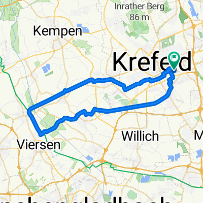
Krefeld - Kloster-Kamp - Krefeld
A cycling route starting in Krefeld, North Rhine-Westphalia, Germany.
Overview
About this route
Am Hülser Berg und auch an Tönisberg vorbei Richtung Norden. Weiter an coolen Kuhlen und Niepen (hier floß mal der Rhein) zum nördlichsten (Höhe-)Punkt - Kloster-Kamp.
Die Rast ist verdient.
Danach durch die Fossa Eugeniana, eine kleine Runde um den Dachsberg und dann Richtung Oermter Berg. Im Ökodorf Rheurdt geht's doch noch bergauf auf die Schaephuysener Höhen und auf und an denen nach Stenden.
Noch ein Bier in der Waldschenke?
Durch die Felder geht's anschließend westlich von Hüls wieder zurück nach Krefeld.
- -:--
- Duration
- 56.9 km
- Distance
- 181 m
- Ascent
- 186 m
- Descent
- ---
- Avg. speed
- 75 m
- Avg. speed
Route quality
Waytypes & surfaces along the route
Waytypes
Quiet road
32.9 km
(58 %)
Track
12 km
(21 %)
Surfaces
Paved
41.8 km
(73 %)
Unpaved
8.1 km
(14 %)
Asphalt
39 km
(68 %)
Gravel
7.2 km
(13 %)
Continue with Bikemap
Use, edit, or download this cycling route
You would like to ride Krefeld - Kloster-Kamp - Krefeld or customize it for your own trip? Here is what you can do with this Bikemap route:
Free features
- Save this route as favorite or in collections
- Copy & plan your own version of this route
- Sync your route with Garmin or Wahoo
Premium features
Free trial for 3 days, or one-time payment. More about Bikemap Premium.
- Navigate this route on iOS & Android
- Export a GPX / KML file of this route
- Create your custom printout (try it for free)
- Download this route for offline navigation
Discover more Premium features.
Get Bikemap PremiumFrom our community
Other popular routes starting in Krefeld
 Three Hills of Hüls
- Distance
- 14 km
- Ascent
- 157 m
- Descent
- 155 m
- Location
- Krefeld, North Rhine-Westphalia, Germany
 Tour von Oppum auf die Schaephuysener Höhen
- Distance
- 45.2 km
- Ascent
- 176 m
- Descent
- 171 m
- Location
- Krefeld, North Rhine-Westphalia, Germany
 Krefeld KulTour
- Distance
- 33.2 km
- Ascent
- 145 m
- Descent
- 147 m
- Location
- Krefeld, North Rhine-Westphalia, Germany
 Schluff Bahntrasse 2
- Distance
- 41.5 km
- Ascent
- 19 m
- Descent
- 21 m
- Location
- Krefeld, North Rhine-Westphalia, Germany
 SüdfrankreichSpanienumrundung 2017 03
- Distance
- 2,085 km
- Ascent
- 1,400 m
- Descent
- 1,413 m
- Location
- Krefeld, North Rhine-Westphalia, Germany
 Picnique im D-Nordpark
- Distance
- 17.2 km
- Ascent
- 35 m
- Descent
- 40 m
- Location
- Krefeld, North Rhine-Westphalia, Germany
 Familientour
- Distance
- 42.9 km
- Ascent
- 74 m
- Descent
- 76 m
- Location
- Krefeld, North Rhine-Westphalia, Germany
 Entspannende Route in Krefeld
- Distance
- 16.7 km
- Ascent
- 681 m
- Descent
- 677 m
- Location
- Krefeld, North Rhine-Westphalia, Germany
Open it in the app