

20151027_111957.gpx
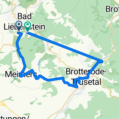
A cycling route starting in Bad Liebenstein, Free State of Thuringia, Germany.
Overview
About this route
TEASI track
- -:--
- Duration
- 49.3 km
- Distance
- 607 m
- Ascent
- 484 m
- Descent
- ---
- Avg. speed
- ---
- Avg. speed
Route quality
Waytypes & surfaces along the route
Waytypes
Track
14.5 km
(30 %)
Quiet road
14.2 km
(29 %)
Surfaces
Paved
31 km
(63 %)
Unpaved
9.5 km
(19 %)
Asphalt
24 km
(49 %)
Gravel
8.7 km
(18 %)
Continue with Bikemap
Use, edit, or download this cycling route
You would like to ride 20151027_111957.gpx or customize it for your own trip? Here is what you can do with this Bikemap route:
Free features
- Save this route as favorite or in collections
- Copy & plan your own version of this route
- Sync your route with Garmin or Wahoo
Premium features
Free trial for 3 days, or one-time payment. More about Bikemap Premium.
- Navigate this route on iOS & Android
- Export a GPX / KML file of this route
- Create your custom printout (try it for free)
- Download this route for offline navigation
Discover more Premium features.
Get Bikemap PremiumFrom our community
Other popular routes starting in Bad Liebenstein
 Bad Liebenstein/Pleß nach Breitungen
- Distance
- 34 km
- Ascent
- 1,428 m
- Descent
- 1,428 m
- Location
- Bad Liebenstein, Free State of Thuringia, Germany
 Gerade Fahrt in Bad Liebenstein
- Distance
- 29.6 km
- Ascent
- 1,519 m
- Descent
- 1,521 m
- Location
- Bad Liebenstein, Free State of Thuringia, Germany
 Barchfelder Straße 37, Bad Liebenstein nach Heinrich-Mann-Straße 30, Bad Liebenstein
- Distance
- 17.3 km
- Ascent
- 225 m
- Descent
- 169 m
- Location
- Bad Liebenstein, Free State of Thuringia, Germany
 Parkstraße 3, Bad Liebenstein nach Parkstraße 3, Bad Liebenstein
- Distance
- 72.9 km
- Ascent
- 1,546 m
- Descent
- 1,544 m
- Location
- Bad Liebenstein, Free State of Thuringia, Germany
 kleine Runde
- Distance
- 17.9 km
- Ascent
- 174 m
- Descent
- 182 m
- Location
- Bad Liebenstein, Free State of Thuringia, Germany
 От Johann-Christian-von-Weiß-Straße 6, Schweina до Am Mühlweg 14, Bad Liebenstein
- Distance
- 19.9 km
- Ascent
- 218 m
- Descent
- 263 m
- Location
- Bad Liebenstein, Free State of Thuringia, Germany
 Route um Bad Liebenstein
- Distance
- 31.4 km
- Ascent
- 833 m
- Descent
- 812 m
- Location
- Bad Liebenstein, Free State of Thuringia, Germany
 Bad Liebenstein/Brotterode/Trusetal/Meimers
- Distance
- 30.7 km
- Ascent
- 800 m
- Descent
- 797 m
- Location
- Bad Liebenstein, Free State of Thuringia, Germany
Open it in the app