
Millertown
A cycling route starting in Folsom, California, United States of America.
Overview
About this route
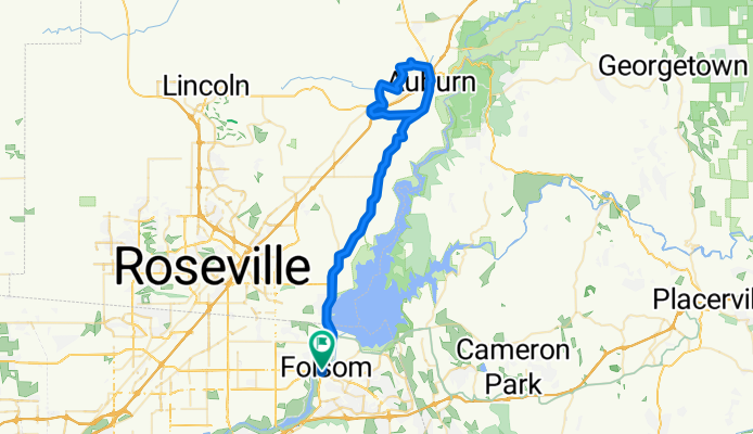
Beginning in Folsom, the 15 miles of 3-4% grades will warm up your legs for the 1 mile 600 ft climb into Auburn. It's not a beast, but you'll feel it, especially early in the climb.
A loop through the western boundary of Auburn and Ophir is idealic for cycling, particularly as you ride Millertown road along the banks of a well shaded creek. The loop closes upon returning to Auburn Folsom road for the 15 mile 3-4% descent back into Folsom. (cloned from route 347377)- -:--
- Duration
- 70.9 km
- Distance
- 636 m
- Ascent
- 635 m
- Descent
- ---
- Avg. speed
- ---
- Avg. speed
Route quality
Waytypes & surfaces along the route
Waytypes
Busy road
47.5 km
(67 %)
Quiet road
7.7 km
(11 %)
Surfaces
Paved
20.3 km
(29 %)
Unpaved
0.4 km
(<1 %)
Asphalt
19.4 km
(27 %)
Concrete
0.8 km
(1 %)
Continue with Bikemap
Use, edit, or download this cycling route
You would like to ride Millertown or customize it for your own trip? Here is what you can do with this Bikemap route:
Free features
- Save this route as favorite or in collections
- Copy & plan your own version of this route
- Sync your route with Garmin or Wahoo
Premium features
Free trial for 3 days, or one-time payment. More about Bikemap Premium.
- Navigate this route on iOS & Android
- Export a GPX / KML file of this route
- Create your custom printout (try it for free)
- Download this route for offline navigation
Discover more Premium features.
Get Bikemap PremiumFrom our community
Other popular routes starting in Folsom
 52 Natoma St, Folsom to 52 Natoma St, Folsom
- Distance
- 13.9 km
- Ascent
- 285 m
- Descent
- 284 m
- Location
- Folsom, California, United States of America
 Lake Natoma Loop from Karen's Bakery
- Distance
- 18.3 km
- Ascent
- 133 m
- Descent
- 130 m
- Location
- Folsom, California, United States of America
 Lake Natoma loop from Intel
- Distance
- 22.1 km
- Ascent
- 158 m
- Descent
- 161 m
- Location
- Folsom, California, United States of America
 2.Folsom crono
- Distance
- 20.7 km
- Ascent
- 338 m
- Descent
- 351 m
- Location
- Folsom, California, United States of America
 Folsom Loop
- Distance
- 25.3 km
- Ascent
- 146 m
- Descent
- 157 m
- Location
- Folsom, California, United States of America
 Downtown Folsom-Johnny Cash Trail-Old Town Sacramento
- Distance
- 58.4 km
- Ascent
- 159 m
- Descent
- 209 m
- Location
- Folsom, California, United States of America
 Folsom Trail Tour
- Distance
- 43 km
- Ascent
- 189 m
- Descent
- 189 m
- Location
- Folsom, California, United States of America
 Short ride from Folsom to Gold River
- Distance
- 9.2 km
- Ascent
- 127 m
- Descent
- 156 m
- Location
- Folsom, California, United States of America
Open it in the app