

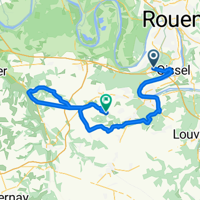
20150806_135533.gpx
A cycling route starting in Grand-Couronne, Normandy, France.
Overview
About this route
TEASI track
- -:--
- Duration
- 110.9 km
- Distance
- 601 m
- Ascent
- 597 m
- Descent
- ---
- Avg. speed
- ---
- Avg. speed
Route quality
Waytypes & surfaces along the route
Waytypes
Busy road
51.4 km
(46 %)
Road
45.7 km
(41 %)
Surfaces
Paved
86.9 km
(78 %)
Asphalt
86.9 km
(78 %)
Concrete
0 km
(<1 %)
Undefined
24 km
(22 %)
Continue with Bikemap
Use, edit, or download this cycling route
You would like to ride 20150806_135533.gpx or customize it for your own trip? Here is what you can do with this Bikemap route:
Free features
- Save this route as favorite or in collections
- Copy & plan your own version of this route
- Sync your route with Garmin or Wahoo
Premium features
Free trial for 3 days, or one-time payment. More about Bikemap Premium.
- Navigate this route on iOS & Android
- Export a GPX / KML file of this route
- Create your custom printout (try it for free)
- Download this route for offline navigation
Discover more Premium features.
Get Bikemap PremiumFrom our community
Other popular routes starting in Grand-Couronne
 France8
- Distance
- 65.7 km
- Ascent
- 269 m
- Descent
- 270 m
- Location
- Grand-Couronne, Normandy, France
 Rouen
Rouen- Distance
- 24 km
- Ascent
- 390 m
- Descent
- 393 m
- Location
- Grand-Couronne, Normandy, France
 saint-etienne du vouvray/X
- Distance
- 252.2 km
- Ascent
- 1,939 m
- Descent
- 1,947 m
- Location
- Grand-Couronne, Normandy, France
 20151022_140405.gpx
- Distance
- 68 km
- Ascent
- 396 m
- Descent
- 389 m
- Location
- Grand-Couronne, Normandy, France
 20150915_135605.gpx
- Distance
- 84.6 km
- Ascent
- 381 m
- Descent
- 380 m
- Location
- Grand-Couronne, Normandy, France
 20150929_135005.gpx
- Distance
- 94.2 km
- Ascent
- 410 m
- Descent
- 413 m
- Location
- Grand-Couronne, Normandy, France
 De Route des Essarts, Oissel à Route de Rouen 14, Darnétal
- Distance
- 12.5 km
- Ascent
- 0 m
- Descent
- 7 m
- Location
- Grand-Couronne, Normandy, France
 20151029_140028.gpx
- Distance
- 77.6 km
- Ascent
- 464 m
- Descent
- 457 m
- Location
- Grand-Couronne, Normandy, France
Open it in the app