

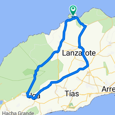
Aufnahme vom 5. November 09:29
A cycling route starting in Tinajo, Canary Islands, Spain.
Overview
About this route
- 2 h 41 min
- Duration
- 49.5 km
- Distance
- 457 m
- Ascent
- 458 m
- Descent
- 18.5 km/h
- Avg. speed
- ---
- Avg. speed

Route quality
Waytypes & surfaces along the route
Waytypes
Busy road
41.4 km
(84 %)
Road
6 km
(12 %)
Surfaces
Paved
48 km
(97 %)
Unpaved
0.3 km
(<1 %)
Asphalt
47.9 km
(97 %)
Ground
0.2 km
(<1 %)
Continue with Bikemap
Use, edit, or download this cycling route
You would like to ride Aufnahme vom 5. November 09:29 or customize it for your own trip? Here is what you can do with this Bikemap route:
Free features
- Save this route as favorite or in collections
- Copy & plan your own version of this route
- Sync your route with Garmin or Wahoo
Premium features
Free trial for 3 days, or one-time payment. More about Bikemap Premium.
- Navigate this route on iOS & Android
- Export a GPX / KML file of this route
- Create your custom printout (try it for free)
- Download this route for offline navigation
Discover more Premium features.
Get Bikemap PremiumFrom our community
Other popular routes starting in Tinajo
 MTB-Tour "Vulkane und Lava"
- Distance
- 30.6 km
- Ascent
- 262 m
- Descent
- 258 m
- Location
- Tinajo, Canary Islands, Spain
 La Santa ascending Los Valles and Tabayesco
- Distance
- 91.2 km
- Ascent
- 1,391 m
- Descent
- 1,385 m
- Location
- Tinajo, Canary Islands, Spain
 Kleine Runde auf Lanzarote
- Distance
- 41.6 km
- Ascent
- 458 m
- Descent
- 384 m
- Location
- Tinajo, Canary Islands, Spain
 IRONMAN 70.3 Lanzarote - Bikesplit <> 2012-11-10
- Distance
- 89.5 km
- Ascent
- 1,089 m
- Descent
- 1,088 m
- Location
- Tinajo, Canary Islands, Spain
 Big loop Lanza
- Distance
- 159.7 km
- Ascent
- 1,600 m
- Descent
- 1,598 m
- Location
- Tinajo, Canary Islands, Spain
 La Santa - Yaiza
- Distance
- 56.6 km
- Ascent
- 577 m
- Descent
- 579 m
- Location
- Tinajo, Canary Islands, Spain
 Nationalpark Timanfaya (Feuerberge)
- Distance
- 56 km
- Ascent
- 589 m
- Descent
- 589 m
- Location
- Tinajo, Canary Islands, Spain
 Nationalpark Timanfaya (Feuerberge)
- Distance
- 56 km
- Ascent
- 594 m
- Descent
- 597 m
- Location
- Tinajo, Canary Islands, Spain
Open it in the app