

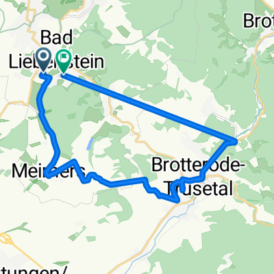
20151105_113705.gpx
A cycling route starting in Bad Liebenstein, Free State of Thuringia, Germany.
Overview
About this route
TEASI track
- -:--
- Duration
- 53.5 km
- Distance
- 512 m
- Ascent
- 512 m
- Descent
- ---
- Avg. speed
- ---
- Avg. speed
Route quality
Waytypes & surfaces along the route
Waytypes
Track
23.2 km
(43 %)
Quiet road
10.5 km
(20 %)
Surfaces
Paved
28.1 km
(53 %)
Unpaved
18.5 km
(35 %)
Asphalt
26.9 km
(50 %)
Gravel
13.3 km
(25 %)
Continue with Bikemap
Use, edit, or download this cycling route
You would like to ride 20151105_113705.gpx or customize it for your own trip? Here is what you can do with this Bikemap route:
Free features
- Save this route as favorite or in collections
- Copy & plan your own version of this route
- Sync your route with Garmin or Wahoo
Premium features
Free trial for 3 days, or one-time payment. More about Bikemap Premium.
- Navigate this route on iOS & Android
- Export a GPX / KML file of this route
- Create your custom printout (try it for free)
- Download this route for offline navigation
Discover more Premium features.
Get Bikemap PremiumFrom our community
Other popular routes starting in Bad Liebenstein
 Parkstraße 3, Bad Liebenstein nach Parkstraße 3, Bad Liebenstein
- Distance
- 72.9 km
- Ascent
- 1,546 m
- Descent
- 1,544 m
- Location
- Bad Liebenstein, Free State of Thuringia, Germany
 Barchfelder Straße 37, Bad Liebenstein nach Heinrich-Mann-Straße 30, Bad Liebenstein
- Distance
- 17.3 km
- Ascent
- 225 m
- Descent
- 169 m
- Location
- Bad Liebenstein, Free State of Thuringia, Germany
 Um Bad liebenstein
- Distance
- 10.4 km
- Ascent
- 251 m
- Descent
- 265 m
- Location
- Bad Liebenstein, Free State of Thuringia, Germany
 Route um Bad Liebenstein
- Distance
- 31.4 km
- Ascent
- 833 m
- Descent
- 812 m
- Location
- Bad Liebenstein, Free State of Thuringia, Germany
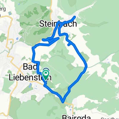
 Bad Liebenstein/Brotterode/Trusetal/Meimers
- Distance
- 30.7 km
- Ascent
- 800 m
- Descent
- 797 m
- Location
- Bad Liebenstein, Free State of Thuringia, Germany
 Gerade Fahrt in Bad Liebenstein
- Distance
- 29.6 km
- Ascent
- 1,519 m
- Descent
- 1,521 m
- Location
- Bad Liebenstein, Free State of Thuringia, Germany
 Bad Liebenstein/Pleß nach Breitungen
- Distance
- 34 km
- Ascent
- 1,428 m
- Descent
- 1,428 m
- Location
- Bad Liebenstein, Free State of Thuringia, Germany
 Friedensallee 1, Bad Liebenstein nach Friedensallee 1, Bad Liebenstein
- Distance
- 5.6 km
- Ascent
- 216 m
- Descent
- 232 m
- Location
- Bad Liebenstein, Free State of Thuringia, Germany
Open it in the app