

20-FEB-11
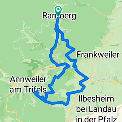
A cycling route starting in Ramberg, Rhineland-Palatinate, Germany.
Overview
About this route
TEASI track
- -:--
- Duration
- 11.1 km
- Distance
- 366 m
- Ascent
- 362 m
- Descent
- ---
- Avg. speed
- ---
- Avg. speed
Route highlights
Points of interest along the route
Point of interest after 2.7 km
20-FEB-11 11:11:09
Point of interest after 3.5 km
20-FEB-11 12:00:56
Point of interest after 5 km
20-FEB-11 12:51:59
Point of interest after 8.9 km
20-FEB-11 13:59:50
Continue with Bikemap
Use, edit, or download this cycling route
You would like to ride 20-FEB-11 or customize it for your own trip? Here is what you can do with this Bikemap route:
Free features
- Save this route as favorite or in collections
- Copy & plan your own version of this route
- Sync your route with Garmin or Wahoo
Premium features
Free trial for 3 days, or one-time payment. More about Bikemap Premium.
- Navigate this route on iOS & Android
- Export a GPX / KML file of this route
- Create your custom printout (try it for free)
- Download this route for offline navigation
Discover more Premium features.
Get Bikemap PremiumFrom our community
Other popular routes starting in Ramberg
 Pfalz_MTB_BurgTrifels
- Distance
- 35.5 km
- Ascent
- 580 m
- Descent
- 580 m
- Location
- Ramberg, Rhineland-Palatinate, Germany
 Rambergrunde 300 HM 20 Km
- Distance
- 20.8 km
- Ascent
- 310 m
- Descent
- 310 m
- Location
- Ramberg, Rhineland-Palatinate, Germany
 Pfalz_MTB_Kalmit
- Distance
- 45.2 km
- Ascent
- 882 m
- Descent
- 882 m
- Location
- Ramberg, Rhineland-Palatinate, Germany
 Pfalz_MTB_Hausrunde
- Distance
- 26.8 km
- Ascent
- 756 m
- Descent
- 745 m
- Location
- Ramberg, Rhineland-Palatinate, Germany
 02-MRZ-13
- Distance
- 11.6 km
- Ascent
- 534 m
- Descent
- 534 m
- Location
- Ramberg, Rhineland-Palatinate, Germany
 Pfalz:_MTB_Weinzapfen
- Distance
- 27.6 km
- Ascent
- 341 m
- Descent
- 352 m
- Location
- Ramberg, Rhineland-Palatinate, Germany
 Heldenstein-Johanniskreuz-Taubensuhl-Heldenstein
- Distance
- 43.4 km
- Ascent
- 773 m
- Descent
- 758 m
- Location
- Ramberg, Rhineland-Palatinate, Germany
 Rambergrunde 20 Km
- Distance
- 21.3 km
- Ascent
- 314 m
- Descent
- 304 m
- Location
- Ramberg, Rhineland-Palatinate, Germany
Open it in the app