

No 1
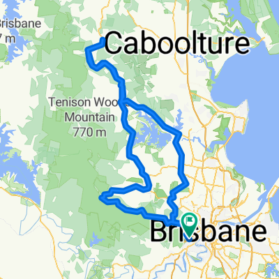
A cycling route starting in Taringa, Queensland, Australia.
Overview
About this route
14/11/2015, 09:18
- 1 h 38 min
- Duration
- 29.7 km
- Distance
- 148 m
- Ascent
- 128 m
- Descent
- 18.2 km/h
- Avg. speed
- ---
- Avg. speed

Continue with Bikemap
Use, edit, or download this cycling route
You would like to ride No 1 or customize it for your own trip? Here is what you can do with this Bikemap route:
Free features
- Save this route as favorite or in collections
- Copy & plan your own version of this route
- Sync your route with Garmin or Wahoo
Premium features
Free trial for 3 days, or one-time payment. More about Bikemap Premium.
- Navigate this route on iOS & Android
- Export a GPX / KML file of this route
- Create your custom printout (try it for free)
- Download this route for offline navigation
Discover more Premium features.
Get Bikemap PremiumFrom our community
Other popular routes starting in Taringa
 Mt Cootha Loop
- Distance
- 9.6 km
- Ascent
- 261 m
- Descent
- 261 m
- Location
- Taringa, Queensland, Australia
 Western Brisbane 67 km River Loop
- Distance
- 67.3 km
- Ascent
- 759 m
- Descent
- 758 m
- Location
- Taringa, Queensland, Australia
 Nebo Samford Dayboro
- Distance
- 117 km
- Ascent
- 862 m
- Descent
- 859 m
- Location
- Taringa, Queensland, Australia
 The Toowong Gateway Loop
- Distance
- 65.2 km
- Ascent
- 5,200 m
- Descent
- 5,200 m
- Location
- Taringa, Queensland, Australia
 28 Ada Street, Toowong to 30 Ada Street, Toowong
- Distance
- 10.9 km
- Ascent
- 0 m
- Descent
- 10 m
- Location
- Taringa, Queensland, Australia
 Mt Cootha finish with breakfast
- Distance
- 5.9 km
- Ascent
- 268 m
- Descent
- 272 m
- Location
- Taringa, Queensland, Australia
 Toowong, Mt Mee, Samford, Mt Nebo loop
- Distance
- 165.9 km
- Ascent
- 1,274 m
- Descent
- 1,271 m
- Location
- Taringa, Queensland, Australia
 Mt Cootha + riverloop
- Distance
- 53.5 km
- Ascent
- 608 m
- Descent
- 626 m
- Location
- Taringa, Queensland, Australia
Open it in the app