

Bad Hall - Rohr im Kremstal (Ortszentren, Umgehung von Hauptverkehrsstraßen)
A cycling route starting in Bad Hall, Upper Austria, Austria.
Overview
About this route
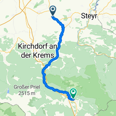
Vom Bad Haller Hauptplatz aus hält man sich kurz Richtung NW, biegt dann nach rechts auf die Römerstraße ab und dann wieder rechts auf die Schulstraße. Nach dem Überqueren der B122 ist dem Radweg zu folgen, der mehr oder weniger parallel zur Straße verläuft. Kurz nach dem Ortsbeginn von Rohr verlässt man den Radweg, biegt nach links auf die Waldstraße, dann rechts auf die B122, welche man nach wenigen Metern wieder nach links verlassen kann und sich nun beim Gemeindeamt befindet.
Dauer: 10-15 Minuten- -:--
- Duration
- 4.4 km
- Distance
- 31 m
- Ascent
- 80 m
- Descent
- ---
- Avg. speed
- ---
- Avg. speed
Route quality
Waytypes & surfaces along the route
Waytypes
Cycleway
1.6 km
(37 %)
Quiet road
1.4 km
(32 %)
Surfaces
Paved
3.2 km
(71 %)
Asphalt
3.2 km
(71 %)
Undefined
1.3 km
(29 %)
Continue with Bikemap
Use, edit, or download this cycling route
You would like to ride Bad Hall - Rohr im Kremstal (Ortszentren, Umgehung von Hauptverkehrsstraßen) or customize it for your own trip? Here is what you can do with this Bikemap route:
Free features
- Save this route as favorite or in collections
- Copy & plan your own version of this route
- Sync your route with Garmin or Wahoo
Premium features
Free trial for 3 days, or one-time payment. More about Bikemap Premium.
- Navigate this route on iOS & Android
- Export a GPX / KML file of this route
- Create your custom printout (try it for free)
- Download this route for offline navigation
Discover more Premium features.
Get Bikemap PremiumFrom our community
Other popular routes starting in Bad Hall
 Steyrtalroute
- Distance
- 56.5 km
- Ascent
- 0 m
- Descent
- 0 m
- Location
- Bad Hall, Upper Austria, Austria
 Bad Hall - Design Center
- Distance
- 37.3 km
- Ascent
- 94 m
- Descent
- 217 m
- Location
- Bad Hall, Upper Austria, Austria
 Rohr Runde
- Distance
- 7.3 km
- Ascent
- 164 m
- Descent
- 174 m
- Location
- Bad Hall, Upper Austria, Austria
 Bad Hall - Jageredt - Runde
- Distance
- 36.1 km
- Ascent
- 227 m
- Descent
- 202 m
- Location
- Bad Hall, Upper Austria, Austria
 Bad Hall - Enns
- Distance
- 67.5 km
- Ascent
- 632 m
- Descent
- 746 m
- Location
- Bad Hall, Upper Austria, Austria
 353 Mostradler 19
- Distance
- 19.4 km
- Ascent
- 170 m
- Descent
- 170 m
- Location
- Bad Hall, Upper Austria, Austria
 5 Flüsse Runde
- Distance
- 105.6 km
- Ascent
- 432 m
- Descent
- 426 m
- Location
- Bad Hall, Upper Austria, Austria
 Knackige Fahrt in Bad Hall
- Distance
- 53.8 km
- Ascent
- 943 m
- Descent
- 943 m
- Location
- Bad Hall, Upper Austria, Austria
Open it in the app