
SALIDA 24 - 24 JULIO 2016
A cycling route starting in Huétor-Tájar, Andalusia, Spain.
Overview
About this route
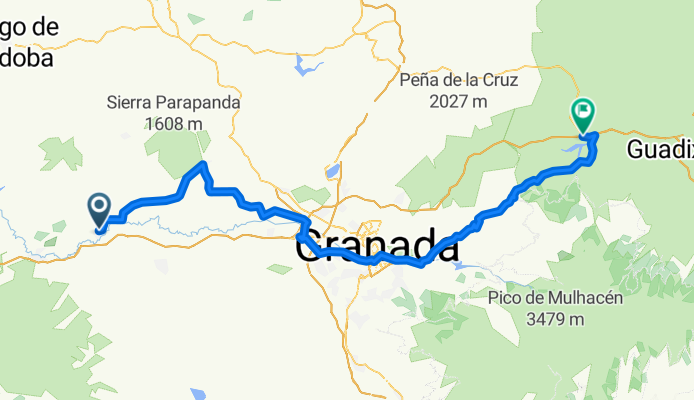
HT – Illora – Valderrubio – Fuente vaqueros – Santa Fe – Belicena – Purchil – GRANADA – Cenes de la Vega – Dudar – Quentar –La Peza – Embalse Franc. Abellan.
REGRESO EN AUTOBUS- -:--
- Duration
- 104.8 km
- Distance
- 1,205 m
- Ascent
- 625 m
- Descent
- ---
- Avg. speed
- ---
- Avg. speed

Route quality
Waytypes & surfaces along the route
Waytypes
Road
74.7 km
(71 %)
Busy road
20.5 km
(20 %)
Surfaces
Paved
89.9 km
(86 %)
Unpaved
0.9 km
(<1 %)
Asphalt
89.7 km
(86 %)
Gravel
0.7 km
(<1 %)
Continue with Bikemap
Use, edit, or download this cycling route
You would like to ride SALIDA 24 - 24 JULIO 2016 or customize it for your own trip? Here is what you can do with this Bikemap route:
Free features
- Save this route as favorite or in collections
- Copy & plan your own version of this route
- Sync your route with Garmin or Wahoo
Premium features
Free trial for 3 days, or one-time payment. More about Bikemap Premium.
- Navigate this route on iOS & Android
- Export a GPX / KML file of this route
- Create your custom printout (try it for free)
- Download this route for offline navigation
Discover more Premium features.
Get Bikemap PremiumFrom our community
Other popular routes starting in Huétor-Tájar
 SALIDA 1_2011
- Distance
- 73.6 km
- Ascent
- 499 m
- Descent
- 499 m
- Location
- Huétor-Tájar, Andalusia, Spain
 SALIDA 10 - 7 ABRIL 2019
- Distance
- 78.6 km
- Ascent
- 732 m
- Descent
- 738 m
- Location
- Huétor-Tájar, Andalusia, Spain
 XXI MARCHA CICLOTURISTA DE HUETOR TAJAR - RECORRIDO CORTO(oficial)
- Distance
- 77.5 km
- Ascent
- 784 m
- Descent
- 785 m
- Location
- Huétor-Tájar, Andalusia, Spain
 Cicloturista Huetor Tájar 2014
- Distance
- 99.8 km
- Ascent
- 1,039 m
- Descent
- 1,039 m
- Location
- Huétor-Tájar, Andalusia, Spain
 SALIDA EN FASE 2 DESESCALADA - Ruta Corta
- Distance
- 95.5 km
- Ascent
- 645 m
- Descent
- 649 m
- Location
- Huétor-Tájar, Andalusia, Spain
 XXI MARCHA CICLOTURISTA DE HUETOR TAJAR (OPCION 2)
- Distance
- 138.7 km
- Ascent
- 1,290 m
- Descent
- 1,288 m
- Location
- Huétor-Tájar, Andalusia, Spain
 SALIDA 4 FEBRERO 2018
- Distance
- 87.8 km
- Ascent
- 495 m
- Descent
- 495 m
- Location
- Huétor-Tájar, Andalusia, Spain
 SALIDA 29 DE ABRIL 2018
- Distance
- 95.3 km
- Ascent
- 633 m
- Descent
- 637 m
- Location
- Huétor-Tájar, Andalusia, Spain
Open it in the app