

Bad Hall - Sierning (Ortszentren, Umgehung von Hauptverkehrsstraßen)
A cycling route starting in Bad Hall, Upper Austria, Austria.
Overview
About this route
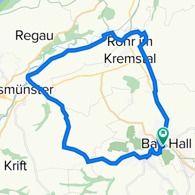
Etwa in der Mitte des Bad Haller Hauptplatzes führt der Weg nach links, die Guntherstraße hinab, über die B138 und den Hallerbach und auf der anderen Seite die Gunterstraße wieder den Hang hinauf und an den Jodbehältern vorbei, von denen aus man schon eine ganz schöne Sicht hat. Nachfolgend geht es steil ins Tal des Fernbaches hinab und nachfolgend wieder hinauf. Im Prinzip kann man dem Straßenverlauf der L1359 nun problemlos fast weiter bis nach Sierning folgen, wobei man durch Großmengersdorf und Mengersdorf, dann durch eine ausgedehnte Waldstrecke. Nach 6 km muss man sich einfach links halten, dann bei der nächsten Gabelung rechts, und schon geht es auf der Schiedlberger Straße hinunter ins Tal nach Sierning. Hierbei würde ich nicht wie abgebildet fahren, sondern eher die Hochstraße hinab und dann nach links, da sich diese Einbahnstraße problemlos befahren lässt.
Dauer: 25-30 Minuten- -:--
- Duration
- 8.8 km
- Distance
- 138 m
- Ascent
- 155 m
- Descent
- ---
- Avg. speed
- ---
- Avg. speed
Route quality
Waytypes & surfaces along the route
Waytypes
Road
7.8 km
(89 %)
Busy road
0.7 km
(8 %)
Surfaces
Paved
6.2 km
(70 %)
Asphalt
6.2 km
(70 %)
Undefined
2.6 km
(30 %)
Continue with Bikemap
Use, edit, or download this cycling route
You would like to ride Bad Hall - Sierning (Ortszentren, Umgehung von Hauptverkehrsstraßen) or customize it for your own trip? Here is what you can do with this Bikemap route:
Free features
- Save this route as favorite or in collections
- Copy & plan your own version of this route
- Sync your route with Garmin or Wahoo
Premium features
Free trial for 3 days, or one-time payment. More about Bikemap Premium.
- Navigate this route on iOS & Android
- Export a GPX / KML file of this route
- Create your custom printout (try it for free)
- Download this route for offline navigation
Discover more Premium features.
Get Bikemap PremiumFrom our community
Other popular routes starting in Bad Hall
 Knackige Fahrt in Bad Hall
- Distance
- 53.8 km
- Ascent
- 943 m
- Descent
- 943 m
- Location
- Bad Hall, Upper Austria, Austria
 Bad Hall - Design Center
- Distance
- 37.3 km
- Ascent
- 94 m
- Descent
- 217 m
- Location
- Bad Hall, Upper Austria, Austria
 Hintergebirge Goashansl Runde
- Distance
- 82.9 km
- Ascent
- 1,053 m
- Descent
- 1,051 m
- Location
- Bad Hall, Upper Austria, Austria
 2025_04_30_Rohr-Wels-Neuhofen-Rohr
- Distance
- 49.5 km
- Ascent
- 452 m
- Descent
- 455 m
- Location
- Bad Hall, Upper Austria, Austria
 2025_05_21_Rohr-Traunbrücke-Kematen-Rohr
- Distance
- 50.1 km
- Ascent
- 535 m
- Descent
- 533 m
- Location
- Bad Hall, Upper Austria, Austria
 Kultur in Bad Hall
- Distance
- 18.7 km
- Ascent
- 204 m
- Descent
- 205 m
- Location
- Bad Hall, Upper Austria, Austria
 5 Flüsse Runde
- Distance
- 105.6 km
- Ascent
- 432 m
- Descent
- 426 m
- Location
- Bad Hall, Upper Austria, Austria
 Bad Hall - Enns
- Distance
- 67.5 km
- Ascent
- 632 m
- Descent
- 746 m
- Location
- Bad Hall, Upper Austria, Austria
Open it in the app