

20151212_135713.gpx
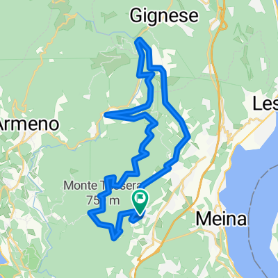
A cycling route starting in Colazza, Piedmont, Italy.
Overview
About this route
TEASI track
- -:--
- Duration
- 17.9 km
- Distance
- 499 m
- Ascent
- 505 m
- Descent
- ---
- Avg. speed
- ---
- Avg. speed
Route quality
Waytypes & surfaces along the route
Waytypes
Quiet road
6.8 km
(38 %)
Road
4.7 km
(27 %)
Surfaces
Paved
12.8 km
(72 %)
Unpaved
2.1 km
(12 %)
Asphalt
12.4 km
(70 %)
Ground
2 km
(11 %)
Continue with Bikemap
Use, edit, or download this cycling route
You would like to ride 20151212_135713.gpx or customize it for your own trip? Here is what you can do with this Bikemap route:
Free features
- Save this route as favorite or in collections
- Copy & plan your own version of this route
- Sync your route with Garmin or Wahoo
Premium features
Free trial for 3 days, or one-time payment. More about Bikemap Premium.
- Navigate this route on iOS & Android
- Export a GPX / KML file of this route
- Create your custom printout (try it for free)
- Download this route for offline navigation
Discover more Premium features.
Get Bikemap PremiumFrom our community
Other popular routes starting in Colazza
 Alto Vergante da Colazza
- Distance
- 30.1 km
- Ascent
- 849 m
- Descent
- 849 m
- Location
- Colazza, Piedmont, Italy
 Mottarone
- Distance
- 44.6 km
- Ascent
- 2,098 m
- Descent
- 2,099 m
- Location
- Colazza, Piedmont, Italy
 Mottarone
- Distance
- 44.6 km
- Ascent
- 2,098 m
- Descent
- 2,099 m
- Location
- Colazza, Piedmont, Italy
 Colazza 3
- Distance
- 2 km
- Ascent
- 29 m
- Descent
- 276 m
- Location
- Colazza, Piedmont, Italy
 Lèzio Lupi
- Distance
- 1.3 km
- Ascent
- 31 m
- Descent
- 184 m
- Location
- Colazza, Piedmont, Italy
 Risalita Colazza
- Distance
- 5.5 km
- Ascent
- 348 m
- Descent
- 108 m
- Location
- Colazza, Piedmont, Italy
 Colazza 2
- Distance
- 2.2 km
- Ascent
- 36 m
- Descent
- 261 m
- Location
- Colazza, Piedmont, Italy
 Colazza 1
- Distance
- 3 km
- Ascent
- 35 m
- Descent
- 240 m
- Location
- Colazza, Piedmont, Italy
Open it in the app