

sunday cycling
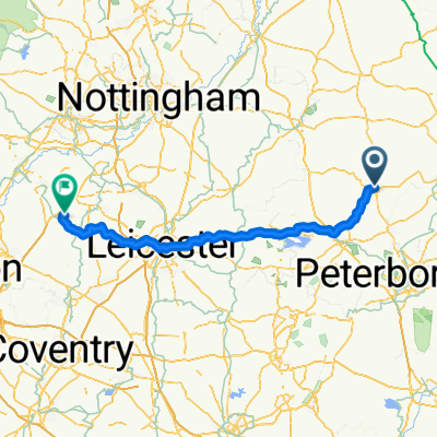
A cycling route starting in Bourne, England, United Kingdom.
Overview
About this route
xx
- -:--
- Duration
- 37.6 km
- Distance
- ---
- Ascent
- ---
- Descent
- ---
- Avg. speed
- ---
- Avg. speed
Route quality
Waytypes & surfaces along the route
Waytypes
Road
15.5 km
(41 %)
Quiet road
13.9 km
(37 %)
Surfaces
Paved
21.2 km
(56 %)
Unpaved
3.6 km
(10 %)
Asphalt
21.1 km
(56 %)
Gravel
3.1 km
(8 %)
Continue with Bikemap
Use, edit, or download this cycling route
You would like to ride sunday cycling or customize it for your own trip? Here is what you can do with this Bikemap route:
Free features
- Save this route as favorite or in collections
- Copy & plan your own version of this route
- Sync your route with Garmin or Wahoo
Premium features
Free trial for 3 days, or one-time payment. More about Bikemap Premium.
- Navigate this route on iOS & Android
- Export a GPX / KML file of this route
- Create your custom printout (try it for free)
- Download this route for offline navigation
Discover more Premium features.
Get Bikemap PremiumFrom our community
Other popular routes starting in Bourne
 sunday cycling
- Distance
- 37.6 km
- Ascent
- ---
- Descent
- ---
- Location
- Bourne, England, United Kingdom
 Bourne Woods Car Park to Bourne Woods Car Park
- Distance
- 7.4 km
- Ascent
- 101 m
- Descent
- 97 m
- Location
- Bourne, England, United Kingdom
 ?‘∞Õ? do ?(¶Õ°?
- Distance
- 20.4 km
- Ascent
- 3 m
- Descent
- 16 m
- Location
- Bourne, England, United Kingdom
 testing nav2
- Distance
- 1.9 km
- Ascent
- 8 m
- Descent
- 4 m
- Location
- Bourne, England, United Kingdom
 Elsea Park Community Centre, 1 Sandown Dr, Bourne to 14 Ascot Close, Bourne
- Distance
- 14.5 km
- Ascent
- 219 m
- Descent
- 215 m
- Location
- Bourne, England, United Kingdom
 06toft-goadby
- Distance
- 49.6 km
- Ascent
- 361 m
- Descent
- 239 m
- Location
- Bourne, England, United Kingdom
 23 High Street, Bourne to 16 East Lane, Bourne
- Distance
- 8.9 km
- Ascent
- 3 m
- Descent
- 13 m
- Location
- Bourne, England, United Kingdom
 bourne-packington kort
- Distance
- 98.2 km
- Ascent
- 505 m
- Descent
- 393 m
- Location
- Bourne, England, United Kingdom
Open it in the app