

Linz nach Prag
A cycling route starting in Linz, Upper Austria, Austria.
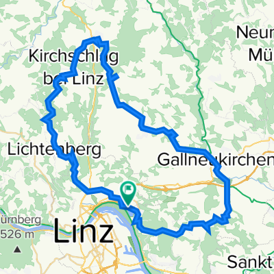
Overview
About this route
Linz nach Prag
1. Tag Bad Leonfelden (40km) Bergauf 2. Tag Ceske Krumlauf (45 km) mit Pause Ceske Budejovice (25 km) auf 110 km Summe: 70km 3. Tag Tabor (65km) auf 175km 4) Trebsin (65) auf 240km 5) Praha (36km) auf 276km- -:--
- Duration
- 276.6 km
- Distance
- 1,220 m
- Ascent
- 1,282 m
- Descent
- ---
- Avg. speed
- ---
- Avg. speed

Route quality
Waytypes & surfaces along the route
Waytypes
Road
97.4 km
(35 %)
Busy road
73.3 km
(27 %)
Surfaces
Paved
165.8 km
(60 %)
Unpaved
14.8 km
(5 %)
Asphalt
160.3 km
(58 %)
Gravel
9.4 km
(3 %)
Continue with Bikemap
Use, edit, or download this cycling route
You would like to ride Linz nach Prag or customize it for your own trip? Here is what you can do with this Bikemap route:
Free features
- Save this route as favorite or in collections
- Copy & plan your own version of this route
- Sync your route with Garmin or Wahoo
Premium features
Free trial for 3 days, or one-time payment. More about Bikemap Premium.
- Navigate this route on iOS & Android
- Export a GPX / KML file of this route
- Create your custom printout (try it for free)
- Download this route for offline navigation
Discover more Premium features.
Get Bikemap PremiumFrom our community
Other popular routes starting in Linz
 Pferdeeisenbahn-Innertreffling-Forst-Pulgarn-Steyregg-Pfenningberg-Plesching
- Distance
- 42.8 km
- Ascent
- 674 m
- Descent
- 677 m
- Location
- Linz, Upper Austria, Austria
 Steyregg Runde
- Distance
- 22 km
- Ascent
- 218 m
- Descent
- 220 m
- Location
- Linz, Upper Austria, Austria
 Lichtenberg, Mirellental, Pfenningberg CLONED FROM ROUTE 38001
- Distance
- 54.3 km
- Ascent
- 1,090 m
- Descent
- 1,093 m
- Location
- Linz, Upper Austria, Austria
 St. Martin- Lichtenhah-Lichtenberg
- Distance
- 73.2 km
- Ascent
- 1,240 m
- Descent
- 1,241 m
- Location
- Linz, Upper Austria, Austria
 Oberbairing-Altenberg-Galli-Linz
- Distance
- 27.8 km
- Ascent
- 496 m
- Descent
- 496 m
- Location
- Linz, Upper Austria, Austria
 4.3.2023
- Distance
- 47.5 km
- Ascent
- 751 m
- Descent
- 749 m
- Location
- Linz, Upper Austria, Austria
 Süden von Linz
- Distance
- 42.4 km
- Ascent
- 186 m
- Descent
- 187 m
- Location
- Linz, Upper Austria, Austria
 Pfenningberg Tour
- Distance
- 28.9 km
- Ascent
- 458 m
- Descent
- 458 m
- Location
- Linz, Upper Austria, Austria
Open it in the app