
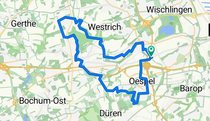
Rundtour Stadtbezirk Lütgendortmund
A cycling route starting in Dortmund, North Rhine-Westphalia, Germany.
Overview
About this route
23 km Rad-Rundkurs Stadtbezirk Dortmund-Lütgendortmund
Roter Pfeil = gegen den Uhrzeigersinn Grüner Pfeil = im Uhrzeigersinn (cloned from route 2957629) (cloned from route 3094655)- -:--
- Duration
- 22.5 km
- Distance
- 149 m
- Ascent
- 148 m
- Descent
- ---
- Avg. speed
- ---
- Avg. speed
Route quality
Waytypes & surfaces along the route
Waytypes
Quiet road
12.2 km
(54 %)
Path
3.3 km
(15 %)
Surfaces
Paved
18 km
(80 %)
Unpaved
3 km
(13 %)
Asphalt
16.9 km
(75 %)
Gravel
2.4 km
(11 %)
Continue with Bikemap
Use, edit, or download this cycling route
You would like to ride Rundtour Stadtbezirk Lütgendortmund or customize it for your own trip? Here is what you can do with this Bikemap route:
Free features
- Save this route as favorite or in collections
- Copy & plan your own version of this route
- Sync your route with Garmin or Wahoo
Premium features
Free trial for 3 days, or one-time payment. More about Bikemap Premium.
- Navigate this route on iOS & Android
- Export a GPX / KML file of this route
- Create your custom printout (try it for free)
- Download this route for offline navigation
Discover more Premium features.
Get Bikemap PremiumFrom our community
Other popular routes starting in Dortmund
 Wellinghofer RTF 41km-Strecke
- Distance
- 39.2 km
- Ascent
- 309 m
- Descent
- 309 m
- Location
- Dortmund, North Rhine-Westphalia, Germany
 Dortmund-Sauerlandrunde Klassik
- Distance
- 128.7 km
- Ascent
- 2,663 m
- Descent
- 2,555 m
- Location
- Dortmund, North Rhine-Westphalia, Germany
 Trautenauer Straße 30, Dortmund nach Trautenauer Straße 30, Dortmund
- Distance
- 17.9 km
- Ascent
- 250 m
- Descent
- 296 m
- Location
- Dortmund, North Rhine-Westphalia, Germany
 Route Eving, Brechten und Lünen
- Distance
- 20.3 km
- Ascent
- 7 m
- Descent
- 11 m
- Location
- Dortmund, North Rhine-Westphalia, Germany
 Rund um den Dortmunder Süden
- Distance
- 61.4 km
- Ascent
- 313 m
- Descent
- 313 m
- Location
- Dortmund, North Rhine-Westphalia, Germany
 Wambel - Hohensyburg
- Distance
- 18 km
- Ascent
- 0 m
- Descent
- 0 m
- Location
- Dortmund, North Rhine-Westphalia, Germany
 Dortmund-Emscherquelle-Kamen-Dortmund
- Distance
- 67.3 km
- Ascent
- 213 m
- Descent
- 206 m
- Location
- Dortmund, North Rhine-Westphalia, Germany
 Rund um den Höchsten
- Distance
- 52.9 km
- Ascent
- 287 m
- Descent
- 284 m
- Location
- Dortmund, North Rhine-Westphalia, Germany
Open it in the app