

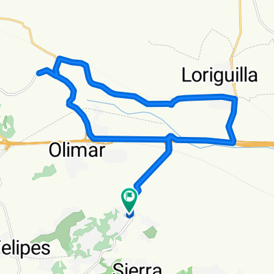
URB. SAN MARTIN - OLOCAU
A cycling route starting in Cheste, Valencia, Spain.
Overview
About this route
RUTA FACIL Y DIVERTIDA BUSCANDO SENDAS SIN COMPLICACIONES.
- -:--
- Duration
- 51.6 km
- Distance
- ---
- Ascent
- ---
- Descent
- ---
- Avg. speed
- ---
- Max. altitude

Route quality
Waytypes & surfaces along the route
Waytypes
Quiet road
22.2 km
(43 %)
Track
20.6 km
(40 %)
Surfaces
Paved
3.6 km
(7 %)
Unpaved
7.7 km
(15 %)
Gravel
6.2 km
(12 %)
Asphalt
3.1 km
(6 %)
Continue with Bikemap
Use, edit, or download this cycling route
You would like to ride URB. SAN MARTIN - OLOCAU or customize it for your own trip? Here is what you can do with this Bikemap route:
Free features
- Save this route as favorite or in collections
- Copy & plan your own version of this route
- Sync your route with Garmin or Wahoo
Premium features
Free trial for 3 days, or one-time payment. More about Bikemap Premium.
- Navigate this route on iOS & Android
- Export a GPX / KML file of this route
- Create your custom printout (try it for free)
- Download this route for offline navigation
Discover more Premium features.
Get Bikemap PremiumFrom our community
Other popular routes starting in Cheste
 prueba carretera
- Distance
- 21.1 km
- Ascent
- 81 m
- Descent
- 117 m
- Location
- Cheste, Valencia, Spain
 Cracking ride in Cheste
- Distance
- 17.9 km
- Ascent
- 167 m
- Descent
- 164 m
- Location
- Cheste, Valencia, Spain
 Cheste - La manga - Viñas - Cheste
- Distance
- 37.1 km
- Ascent
- 559 m
- Descent
- 559 m
- Location
- Cheste, Valencia, Spain
 Camping - Cheste - Circuit - Carambolo
- Distance
- 19.5 km
- Ascent
- 177 m
- Descent
- 173 m
- Location
- Cheste, Valencia, Spain
 cheste-viñas-corrales-cuchillo-visos-barranco hondo-cheste
- Distance
- 25 km
- Ascent
- 441 m
- Descent
- 442 m
- Location
- Cheste, Valencia, Spain
 calicanto montaña
- Distance
- 29.2 km
- Ascent
- 318 m
- Descent
- 315 m
- Location
- Cheste, Valencia, Spain
 URB. SAN MARTIN - OLOCAU
- Distance
- 51.6 km
- Ascent
- ---
- Descent
- ---
- Location
- Cheste, Valencia, Spain
 Camping - Cheste - Corrales - Pino - Mojete
- Distance
- 44.1 km
- Ascent
- 597 m
- Descent
- 594 m
- Location
- Cheste, Valencia, Spain
Open it in the app