

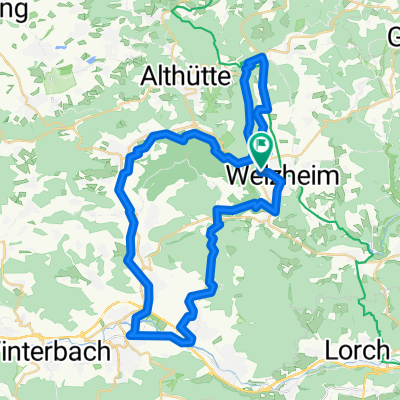
Welzheim - Aichstruter Stausee - Kaisersbach - Täle - Hagerwaldsee - Wahlenheim - Alfdorf - Welzheim
A cycling route starting in Welzheim, Baden-Württemberg, Germany.
Overview
About this route
None
(cloned from route 186749)
- -:--
- Duration
- 34.4 km
- Distance
- 375 m
- Ascent
- 374 m
- Descent
- ---
- Avg. speed
- ---
- Avg. speed
Route quality
Waytypes & surfaces along the route
Waytypes
Road
12 km
(35 %)
Busy road
6.5 km
(19 %)
Surfaces
Paved
25.8 km
(75 %)
Unpaved
1.8 km
(5 %)
Asphalt
23.4 km
(68 %)
Paved (undefined)
2.5 km
(7 %)
Continue with Bikemap
Use, edit, or download this cycling route
You would like to ride Welzheim - Aichstruter Stausee - Kaisersbach - Täle - Hagerwaldsee - Wahlenheim - Alfdorf - Welzheim or customize it for your own trip? Here is what you can do with this Bikemap route:
Free features
- Save this route as favorite or in collections
- Copy & plan your own version of this route
- Sync your route with Garmin or Wahoo
Premium features
Free trial for 3 days, or one-time payment. More about Bikemap Premium.
- Navigate this route on iOS & Android
- Export a GPX / KML file of this route
- Create your custom printout (try it for free)
- Download this route for offline navigation
Discover more Premium features.
Get Bikemap PremiumFrom our community
Other popular routes starting in Welzheim
 Welzheim-Waldenburg
- Distance
- 142.5 km
- Ascent
- 1,589 m
- Descent
- 1,613 m
- Location
- Welzheim, Baden-Württemberg, Germany
 Tour 2 Waldenburg
- Distance
- 161.7 km
- Ascent
- 1,390 m
- Descent
- 1,451 m
- Location
- Welzheim, Baden-Württemberg, Germany
 Tour 3 Löwenstein
- Distance
- 111.3 km
- Ascent
- 1,666 m
- Descent
- 1,653 m
- Location
- Welzheim, Baden-Württemberg, Germany
 murrhardt Backnang Ebnisee
- Distance
- 68.1 km
- Ascent
- 809 m
- Descent
- 795 m
- Location
- Welzheim, Baden-Württemberg, Germany
 Tour 7 Schwäb. Fränkischer Wald
- Distance
- 152 km
- Ascent
- 2,704 m
- Descent
- 2,781 m
- Location
- Welzheim, Baden-Württemberg, Germany
 rund um Welzheim (incl. Ebnisee/Kastell)
- Distance
- 36.7 km
- Ascent
- 532 m
- Descent
- 523 m
- Location
- Welzheim, Baden-Württemberg, Germany
 Wieslauftal-Runde
- Distance
- 49.1 km
- Ascent
- 425 m
- Descent
- 422 m
- Location
- Welzheim, Baden-Württemberg, Germany
 Einfache Fahrt in Welzheim
- Distance
- 18.6 km
- Ascent
- 272 m
- Descent
- 217 m
- Location
- Welzheim, Baden-Württemberg, Germany
Open it in the app