

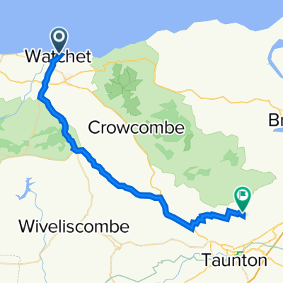
Doniford - Tarr Steps
A cycling route starting in Watchet, England, United Kingdom.
Overview
About this route
Route between Doniford and Tarr Steps.
- -:--
- Duration
- 31.8 km
- Distance
- ---
- Ascent
- ---
- Descent
- ---
- Avg. speed
- ---
- Avg. speed

Route quality
Waytypes & surfaces along the route
Waytypes
Quiet road
21.8 km
(69 %)
Road
5.4 km
(17 %)
Surfaces
Paved
1.4 km
(4 %)
Unpaved
1.2 km
(4 %)
Ground
1.2 km
(4 %)
Paved (undefined)
1.1 km
(4 %)
Continue with Bikemap
Use, edit, or download this cycling route
You would like to ride Doniford - Tarr Steps or customize it for your own trip? Here is what you can do with this Bikemap route:
Free features
- Save this route as favorite or in collections
- Copy & plan your own version of this route
- Sync your route with Garmin or Wahoo
Premium features
Free trial for 3 days, or one-time payment. More about Bikemap Premium.
- Navigate this route on iOS & Android
- Export a GPX / KML file of this route
- Create your custom printout (try it for free)
- Download this route for offline navigation
Discover more Premium features.
Get Bikemap PremiumFrom our community
Other popular routes starting in Watchet
 c2c somerset
- Distance
- 84.7 km
- Ascent
- 640 m
- Descent
- 643 m
- Location
- Watchet, England, United Kingdom
 Doniford - Tarr Steps
- Distance
- 31.8 km
- Ascent
- ---
- Descent
- ---
- Location
- Watchet, England, United Kingdom
 B3191, Blue Anchor, Minehead to South West Coast Path, Porlock, Minehead
- Distance
- 22.3 km
- Ascent
- 266 m
- Descent
- 279 m
- Location
- Watchet, England, United Kingdom
 17 Greenfield Road, Watchet to Dean's Lane, Lydeard St Lawrence, Taunton
- Distance
- 14.5 km
- Ascent
- 221 m
- Descent
- 92 m
- Location
- Watchet, England, United Kingdom
 The Esplanade 1 to Park Gate 5, Cheddon Fitzpaine
- Distance
- 32.7 km
- Ascent
- 124 m
- Descent
- 232 m
- Location
- Watchet, England, United Kingdom
 Exmoor Gravel
- Distance
- 50.3 km
- Ascent
- 1,170 m
- Descent
- 1,169 m
- Location
- Watchet, England, United Kingdom
 Blue Anchor Bay Road to Taunton Station Bridge
- Distance
- 35 km
- Ascent
- 367 m
- Descent
- 356 m
- Location
- Watchet, England, United Kingdom
 aaaaaaa
- Distance
- 26.9 km
- Ascent
- 404 m
- Descent
- 397 m
- Location
- Watchet, England, United Kingdom
Open it in the app