

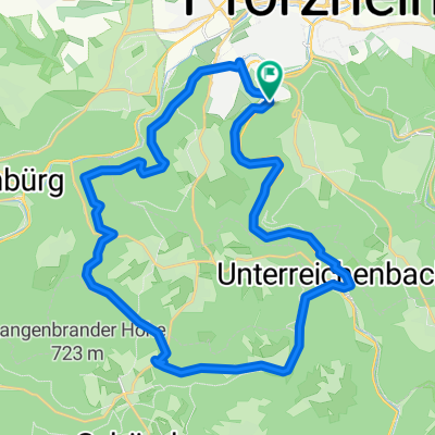
von Pforzheim über Dobel zur Grünhütte
A cycling route starting in Pforzheim, Baden-Württemberg, Germany.
Overview
About this route
Pforzheim-Neuenbürg-Dobel-Grünhütte-Wildbad-Neuenbürg-Pforzheim
kernig, steiler Anstieg in Neuenbürg,
danach stetiger Anstieg über Schwanner Warte bis Dobel, Abfahrt ins Eyachtal und Aufstieg zur Grünhütte. Rückfahrt an der Enz entlang über Wildbad, Calmbach, Neuenbürg nach Pforzheim
(cloned from route 1032206)
- -:--
- Duration
- 71.6 km
- Distance
- 1,019 m
- Ascent
- 1,019 m
- Descent
- ---
- Avg. speed
- ---
- Avg. speed
Route quality
Waytypes & surfaces along the route
Waytypes
Track
43.8 km
(61 %)
Quiet road
15 km
(21 %)
Surfaces
Paved
21.2 km
(30 %)
Unpaved
43.4 km
(61 %)
Gravel
32.3 km
(45 %)
Asphalt
16 km
(22 %)
Continue with Bikemap
Use, edit, or download this cycling route
You would like to ride von Pforzheim über Dobel zur Grünhütte or customize it for your own trip? Here is what you can do with this Bikemap route:
Free features
- Save this route as favorite or in collections
- Copy & plan your own version of this route
- Sync your route with Garmin or Wahoo
Premium features
Free trial for 3 days, or one-time payment. More about Bikemap Premium.
- Navigate this route on iOS & Android
- Export a GPX / KML file of this route
- Create your custom printout (try it for free)
- Download this route for offline navigation
Discover more Premium features.
Get Bikemap PremiumFrom our community
Other popular routes starting in Pforzheim
 Nagoldtal-Würmtal-Runde
- Distance
- 49.4 km
- Ascent
- 605 m
- Descent
- 605 m
- Location
- Pforzheim, Baden-Württemberg, Germany
 Pforzheim - Loßburg
- Distance
- 107.2 km
- Ascent
- 1,198 m
- Descent
- 773 m
- Location
- Pforzheim, Baden-Württemberg, Germany
 Um den Hohberg
- Distance
- 12.4 km
- Ascent
- 160 m
- Descent
- 149 m
- Location
- Pforzheim, Baden-Württemberg, Germany
 dillstein grössel langenbrand U.reichenbach
- Distance
- 31.2 km
- Ascent
- 517 m
- Descent
- 516 m
- Location
- Pforzheim, Baden-Württemberg, Germany
 Gottschalckrunde
- Distance
- 21.4 km
- Ascent
- 486 m
- Descent
- 506 m
- Location
- Pforzheim, Baden-Württemberg, Germany
 Route zu Die Halde
- Distance
- 195.2 km
- Ascent
- 4,988 m
- Descent
- 4,109 m
- Location
- Pforzheim, Baden-Württemberg, Germany
 Pforzheim - Lossburg
- Distance
- 85 km
- Ascent
- 925 m
- Descent
- 521 m
- Location
- Pforzheim, Baden-Württemberg, Germany
 Ulrichstraße 31, Pforzheim to In der Binne 17, Pforzheim
- Distance
- 7.2 km
- Ascent
- 123 m
- Descent
- 174 m
- Location
- Pforzheim, Baden-Württemberg, Germany
Open it in the app