

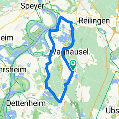
Wiesental-Speyer-Germesheim-Wiesental
A cycling route starting in Waghäusel, Baden-Württemberg, Germany.
Overview
About this route
Schöne Route am Rhein entlang. Die grösste Schwierigkeit liegt im Gegenwind. :-)
(cloned from route 2348638)- -:--
- Duration
- 58.2 km
- Distance
- 106 m
- Ascent
- 107 m
- Descent
- ---
- Avg. speed
- ---
- Avg. speed
Continue with Bikemap
Use, edit, or download this cycling route
You would like to ride Wiesental-Speyer-Germesheim-Wiesental or customize it for your own trip? Here is what you can do with this Bikemap route:
Free features
- Save this route as favorite or in collections
- Copy & plan your own version of this route
- Sync your route with Garmin or Wahoo
Premium features
Free trial for 3 days, or one-time payment. More about Bikemap Premium.
- Navigate this route on iOS & Android
- Export a GPX / KML file of this route
- Create your custom printout (try it for free)
- Download this route for offline navigation
Discover more Premium features.
Get Bikemap PremiumFrom our community
Other popular routes starting in Waghäusel
 Lange Trainingsrunde
- Distance
- 64.5 km
- Ascent
- 134 m
- Descent
- 131 m
- Location
- Waghäusel, Baden-Württemberg, Germany
 Durch den Wald zwischen Kirrlach, Kronau und St. Leon
- Distance
- 26.6 km
- Ascent
- 134 m
- Descent
- 132 m
- Location
- Waghäusel, Baden-Württemberg, Germany
 St. Leon - Kronau
- Distance
- 24.5 km
- Ascent
- 81 m
- Descent
- 81 m
- Location
- Waghäusel, Baden-Württemberg, Germany
 Kapellentour - ab/bis Kirrlach
- Distance
- 65.1 km
- Ascent
- 434 m
- Descent
- 437 m
- Location
- Waghäusel, Baden-Württemberg, Germany
 Große Kraichgaurunde
- Distance
- 78.7 km
- Ascent
- 299 m
- Descent
- 301 m
- Location
- Waghäusel, Baden-Württemberg, Germany
 Waghäusel-Wiesloch Rundfahrt
- Distance
- 42.8 km
- Ascent
- 99 m
- Descent
- 99 m
- Location
- Waghäusel, Baden-Württemberg, Germany
 Kirrlach Malschenberg und zurück
- Distance
- 38.2 km
- Ascent
- 134 m
- Descent
- 133 m
- Location
- Waghäusel, Baden-Württemberg, Germany
 Feierabendrunde
- Distance
- 35.5 km
- Ascent
- 34 m
- Descent
- 36 m
- Location
- Waghäusel, Baden-Württemberg, Germany
Open it in the app