

Alte Hohe Straße, Kirnitzsch- und Schwarzbachtal
A cycling route starting in Sebnitz, Saxony, Germany.
Overview
About this route
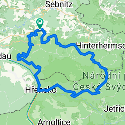
Nachmittagsrunde ab Sebnitz auf einem Teil der Alten Hohenstraße zwischen Lichenhain und Waldhaus Hertigswalde, weiter durch das Kirnitzschtal bis Bad Schandau und danach entlang von Lachs- und Sebnitzbach nach Kohlmühle. Von dort aus geht es zunächst auf einem Wiesenweg zur alten Bahnstrecke durch das Schwarzbachtal und auf dem alten Bahndamm über ein Viadukt und zwei Tunnel talaufwärts in Richtung Lohsdorf. Achtung: im oberer Teil des "Railtrails" den besseren der beiden nahezu parallelen Weg benutzen (auf der Karte war nicht festzustellen, welcher genau das ist - deshalb nur aus dem Gedächtnis aufgezeichnet). Zurück über Ulbersdorf nach Sebnitz.
- -:--
- Duration
- 43.8 km
- Distance
- 586 m
- Ascent
- 586 m
- Descent
- ---
- Avg. speed
- ---
- Avg. speed

Route quality
Waytypes & surfaces along the route
Waytypes
Busy road
24.6 km
(56 %)
Track
10.4 km
(24 %)
Surfaces
Paved
31.4 km
(72 %)
Unpaved
10.8 km
(25 %)
Asphalt
31.3 km
(72 %)
Gravel
8.1 km
(19 %)
Continue with Bikemap
Use, edit, or download this cycling route
You would like to ride Alte Hohe Straße, Kirnitzsch- und Schwarzbachtal or customize it for your own trip? Here is what you can do with this Bikemap route:
Free features
- Save this route as favorite or in collections
- Copy & plan your own version of this route
- Sync your route with Garmin or Wahoo
Premium features
Free trial for 3 days, or one-time payment. More about Bikemap Premium.
- Navigate this route on iOS & Android
- Export a GPX / KML file of this route
- Create your custom printout (try it for free)
- Download this route for offline navigation
Discover more Premium features.
Get Bikemap PremiumFrom our community
Other popular routes starting in Sebnitz
 110 km Sparkassen Panorama- RADtour
- Distance
- 101.1 km
- Ascent
- 1,097 m
- Descent
- 1,097 m
- Location
- Sebnitz, Saxony, Germany
 Hinterhermsdorf-Panoramaweg-Bad Schandau-Nationalpark
- Distance
- 46.1 km
- Ascent
- 693 m
- Descent
- 693 m
- Location
- Sebnitz, Saxony, Germany
 Panoramatour Sächsische Schweiz
- Distance
- 56.3 km
- Ascent
- 581 m
- Descent
- 581 m
- Location
- Sebnitz, Saxony, Germany
 Grenzerfahrung III - Unvollständig
- Distance
- 51.7 km
- Ascent
- 803 m
- Descent
- 800 m
- Location
- Sebnitz, Saxony, Germany
 Lehmhübelweg, Sebnitz nach Bad Schandau, Bad Schandau
- Distance
- 21.3 km
- Ascent
- 349 m
- Descent
- 616 m
- Location
- Sebnitz, Saxony, Germany
 Hinterhermsdorf - Ruppersdorf
- Distance
- 65.6 km
- Ascent
- 571 m
- Descent
- 618 m
- Location
- Sebnitz, Saxony, Germany
 Zeughaus, Zeidlertal, Tanzplan
- Distance
- 46.2 km
- Ascent
- 696 m
- Descent
- 697 m
- Location
- Sebnitz, Saxony, Germany
 Kleines Prebischtor, Var. 2
- Distance
- 46.8 km
- Ascent
- 586 m
- Descent
- 586 m
- Location
- Sebnitz, Saxony, Germany
Open it in the app