

Weser-Radweg, 06.Etappe: Von Rinteln bis Bad Oeynhausen
A cycling route starting in Rinteln, Lower Saxony, Germany.
Overview
About this route
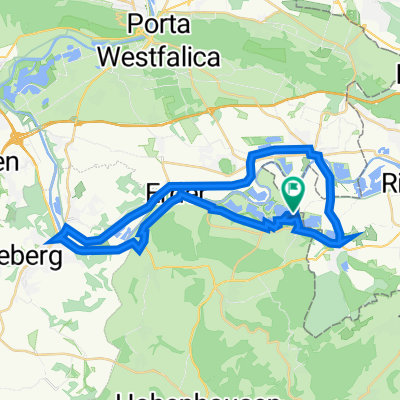
Auf der 26 km langen Etappe erwartet Sie ein abwechslungsreiches Programm. Die ehemalige Universitäts und Festungsstadt Rinteln lockt heute mit buten Fachwerkhäusern und dem sehenswerten historischen Marktplatz. Direkt hinter Rinteln lädt das Erholungsungsgebiet Doktorsee zu einer kurzen Verschnaufpause. Bückeburg liegt zwar nicht direkt am Weser-Radweg aber mit den vielen Sehenswürdigkeiten wie dem Schloss, der Fürstlichen Hofreitschule und dem Hubschraubermuseum lohnt sich ein Tagesausflug. Vorbei an Vlotho geht es zum Etappenziel Bad Oeyenhausen.
- -:--
- Duration
- 26.3 km
- Distance
- 75 m
- Ascent
- 85 m
- Descent
- ---
- Avg. speed
- ---
- Avg. speed
Route quality
Waytypes & surfaces along the route
Waytypes
Quiet road
15 km
(57 %)
Busy road
6.1 km
(23 %)
Surfaces
Paved
25.4 km
(97 %)
Unpaved
0.3 km
(1 %)
Asphalt
24.7 km
(94 %)
Paving stones
0.6 km
(2 %)
Continue with Bikemap
Use, edit, or download this cycling route
You would like to ride Weser-Radweg, 06.Etappe: Von Rinteln bis Bad Oeynhausen or customize it for your own trip? Here is what you can do with this Bikemap route:
Free features
- Save this route as favorite or in collections
- Copy & plan your own version of this route
- Sync your route with Garmin or Wahoo
Premium features
Free trial for 3 days, or one-time payment. More about Bikemap Premium.
- Navigate this route on iOS & Android
- Export a GPX / KML file of this route
- Create your custom printout (try it for free)
- Download this route for offline navigation
Discover more Premium features.
Get Bikemap PremiumFrom our community
Other popular routes starting in Rinteln
 Auf dem höchsten Punkt am Ludwigsturm eine super Aussicht
- Distance
- 22 km
- Ascent
- 357 m
- Descent
- 357 m
- Location
- Rinteln, Lower Saxony, Germany
 Wiemerrunde
- Distance
- 47.6 km
- Ascent
- 378 m
- Descent
- 380 m
- Location
- Rinteln, Lower Saxony, Germany
 Rinteln - Hameln
- Distance
- 54.8 km
- Ascent
- 65 m
- Descent
- 64 m
- Location
- Rinteln, Lower Saxony, Germany
 Rundweg Rinteln/Möllenbeck/Exten/Rinteln
- Distance
- 15.4 km
- Ascent
- 26 m
- Descent
- 26 m
- Location
- Rinteln, Lower Saxony, Germany
 Rinteln Hameln 1-61km
- Distance
- 60.3 km
- Ascent
- 74 m
- Descent
- 76 m
- Location
- Rinteln, Lower Saxony, Germany
 Ein bischen zum Trödeln
- Distance
- 39.9 km
- Ascent
- 489 m
- Descent
- 419 m
- Location
- Rinteln, Lower Saxony, Germany
 Vom Campingpark Kalletal über Vlotho, Veltheim und Möllenbeck
- Distance
- 34.7 km
- Ascent
- 178 m
- Descent
- 180 m
- Location
- Rinteln, Lower Saxony, Germany
 WIIDDIEBTRACK12:37 PM
- Distance
- 13.1 km
- Ascent
- 300 m
- Descent
- 299 m
- Location
- Rinteln, Lower Saxony, Germany
Open it in the app