
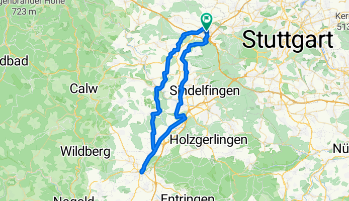
Leonberg-Herrenberg-Leonberg
A cycling route starting in Leonberg, Baden-Württemberg, Germany.
Overview
About this route
- -:--
- Duration
- 64.7 km
- Distance
- 457 m
- Ascent
- 457 m
- Descent
- ---
- Avg. speed
- ---
- Avg. speed
Route quality
Waytypes & surfaces along the route
Waytypes
Track
20.8 km
(32 %)
Quiet road
18.9 km
(29 %)
Surfaces
Paved
56 km
(86 %)
Unpaved
6.4 km
(10 %)
Asphalt
51.8 km
(80 %)
Loose gravel
3.1 km
(5 %)
Continue with Bikemap
Use, edit, or download this cycling route
You would like to ride Leonberg-Herrenberg-Leonberg or customize it for your own trip? Here is what you can do with this Bikemap route:
Free features
- Save this route as favorite or in collections
- Copy & plan your own version of this route
- Sync your route with Garmin or Wahoo
Premium features
Free trial for 3 days, or one-time payment. More about Bikemap Premium.
- Navigate this route on iOS & Android
- Export a GPX / KML file of this route
- Create your custom printout (try it for free)
- Download this route for offline navigation
Discover more Premium features.
Get Bikemap PremiumFrom our community
Other popular routes starting in Leonberg
 Gerade Fahrt in Leonberg
- Distance
- 28.1 km
- Ascent
- 573 m
- Descent
- 516 m
- Location
- Leonberg, Baden-Württemberg, Germany
 Sabine Leonberg
- Distance
- 49.3 km
- Ascent
- 480 m
- Descent
- 480 m
- Location
- Leonberg, Baden-Württemberg, Germany
 Brauhaus-Tour
- Distance
- 21.4 km
- Ascent
- 210 m
- Descent
- 99 m
- Location
- Leonberg, Baden-Württemberg, Germany
 Leonberg Tour de Natur 2008-Final
- Distance
- 35.6 km
- Ascent
- 335 m
- Descent
- 278 m
- Location
- Leonberg, Baden-Württemberg, Germany
 Enztal und Schwarzwald
- Distance
- 102.9 km
- Ascent
- 1,122 m
- Descent
- 1,122 m
- Location
- Leonberg, Baden-Württemberg, Germany
 Tour de Natur 2012
- Distance
- 27.2 km
- Ascent
- 212 m
- Descent
- 209 m
- Location
- Leonberg, Baden-Württemberg, Germany
 Meine ersten fast 50 Kilometer
- Distance
- 49.2 km
- Ascent
- 523 m
- Descent
- 486 m
- Location
- Leonberg, Baden-Württemberg, Germany
 Sabine Leonberg , grüner Heiner
- Distance
- 45 km
- Ascent
- 382 m
- Descent
- 383 m
- Location
- Leonberg, Baden-Württemberg, Germany
Open it in the app