

20160408_103110.gpx
A cycling route starting in Hofheim am Taunus, Hesse, Germany.
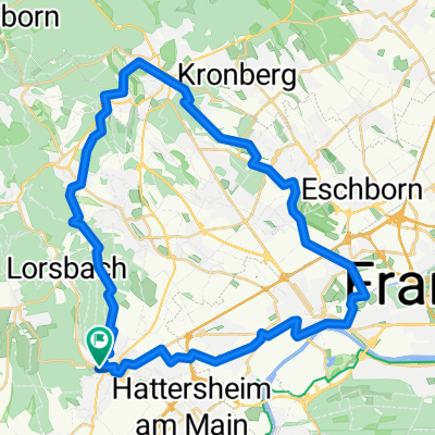
Overview
About this route
TEASI track
- -:--
- Duration
- 66 km
- Distance
- 140 m
- Ascent
- 140 m
- Descent
- ---
- Avg. speed
- ---
- Avg. speed

Continue with Bikemap
Use, edit, or download this cycling route
You would like to ride 20160408_103110.gpx or customize it for your own trip? Here is what you can do with this Bikemap route:
Free features
- Save this route as favorite or in collections
- Copy & plan your own version of this route
- Sync your route with Garmin or Wahoo
Premium features
Free trial for 3 days, or one-time payment. More about Bikemap Premium.
- Navigate this route on iOS & Android
- Export a GPX / KML file of this route
- Create your custom printout (try it for free)
- Download this route for offline navigation
Discover more Premium features.
Get Bikemap PremiumFrom our community
Other popular routes starting in Hofheim am Taunus
 Langenhain, Diedenbergen, Wallau, Langenhain
- Distance
- 15.6 km
- Ascent
- 401 m
- Descent
- 355 m
- Location
- Hofheim am Taunus, Hesse, Germany
 fuchstanz
- Distance
- 43 km
- Ascent
- 764 m
- Descent
- 769 m
- Location
- Hofheim am Taunus, Hesse, Germany
 Hofheim-Flughafen 40km
- Distance
- 39.9 km
- Ascent
- 126 m
- Descent
- 126 m
- Location
- Hofheim am Taunus, Hesse, Germany
 Kids_Runde_190420
- Distance
- 43.3 km
- Ascent
- 407 m
- Descent
- 409 m
- Location
- Hofheim am Taunus, Hesse, Germany
 Einfache Fahrt in Hofheim am Taunus
- Distance
- 19.7 km
- Ascent
- 488 m
- Descent
- 489 m
- Location
- Hofheim am Taunus, Hesse, Germany
 Hfm-Lgh-Epp_Lob-Hof (19km)
- Distance
- 19.5 km
- Ascent
- 406 m
- Descent
- 406 m
- Location
- Hofheim am Taunus, Hesse, Germany
 Narturpark
- Distance
- 33.4 km
- Ascent
- 364 m
- Descent
- 380 m
- Location
- Hofheim am Taunus, Hesse, Germany
 Übers Eselseck
- Distance
- 52.7 km
- Ascent
- 843 m
- Descent
- 797 m
- Location
- Hofheim am Taunus, Hesse, Germany
Open it in the app