

20160507_100933.gpx
A cycling route starting in Heubach, Baden-Württemberg, Germany.
Overview
About this route
TEASI track
- -:--
- Duration
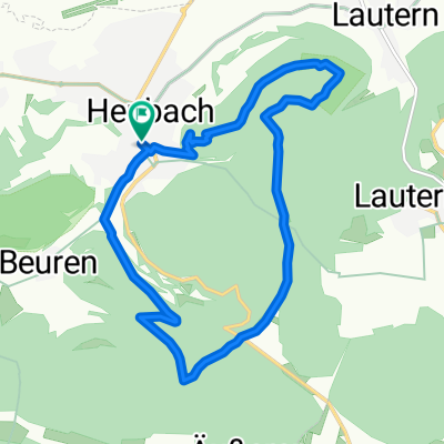
- 9.3 km
- Distance
- 480 m
- Ascent
- 482 m
- Descent
- ---
- Avg. speed
- ---
- Avg. speed

Continue with Bikemap
Use, edit, or download this cycling route
You would like to ride 20160507_100933.gpx or customize it for your own trip? Here is what you can do with this Bikemap route:
Free features
- Save this route as favorite or in collections
- Copy & plan your own version of this route
- Sync your route with Garmin or Wahoo
Premium features
Free trial for 3 days, or one-time payment. More about Bikemap Premium.
- Navigate this route on iOS & Android
- Export a GPX / KML file of this route
- Create your custom printout (try it for free)
- Download this route for offline navigation
Discover more Premium features.
Get Bikemap PremiumFrom our community
Other popular routes starting in Heubach
 GD02 Steilabfall und Keuperhöhe
- Distance
- 41.5 km
- Ascent
- 333 m
- Descent
- 335 m
- Location
- Heubach, Baden-Württemberg, Germany
 Bargau - Tauchernweiler
- Distance
- 37 km
- Ascent
- 506 m
- Descent
- 508 m
- Location
- Heubach, Baden-Württemberg, Germany
 himmelreich - bartholomä - rosenstein
- Distance
- 19.7 km
- Ascent
- 431 m
- Descent
- 431 m
- Location
- Heubach, Baden-Württemberg, Germany
 tauchenweiler 40
- Distance
- 39.4 km
- Ascent
- 612 m
- Descent
- 612 m
- Location
- Heubach, Baden-Württemberg, Germany
 Rosenstein,Kaltes Feld,Drei Kaiserberge
- Distance
- 35.8 km
- Ascent
- 511 m
- Descent
- 745 m
- Location
- Heubach, Baden-Württemberg, Germany
 Unbenannte Route
- Distance
- 30.4 km
- Ascent
- 535 m
- Descent
- 534 m
- Location
- Heubach, Baden-Württemberg, Germany
 Rupprtshofen
- Distance
- 43.7 km
- Ascent
- 372 m
- Descent
- 372 m
- Location
- Heubach, Baden-Württemberg, Germany
 09_teufelsklinge
- Distance
- 12.4 km
- Ascent
- 464 m
- Descent
- 464 m
- Location
- Heubach, Baden-Württemberg, Germany
Open it in the app