

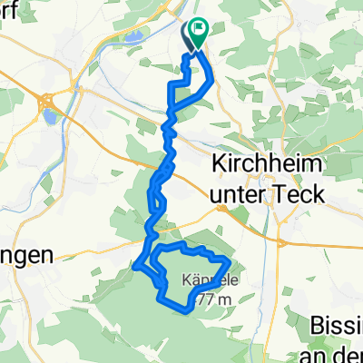
20160430_155519.gpx
A cycling route starting in Wernau, Baden-Württemberg, Germany.
Overview
About this route
TEASI track
- -:--
- Duration
- 20.2 km
- Distance
- 316 m
- Ascent
- 316 m
- Descent
- ---
- Avg. speed
- ---
- Avg. speed

Route quality
Waytypes & surfaces along the route
Waytypes
Track
12.7 km
(63 %)
Quiet road
4.2 km
(21 %)
Surfaces
Paved
11 km
(54 %)
Unpaved
6.1 km
(30 %)
Asphalt
8.3 km
(41 %)
Gravel
3.9 km
(19 %)
Continue with Bikemap
Use, edit, or download this cycling route
You would like to ride 20160430_155519.gpx or customize it for your own trip? Here is what you can do with this Bikemap route:
Free features
- Save this route as favorite or in collections
- Copy & plan your own version of this route
- Sync your route with Garmin or Wahoo
Premium features
Free trial for 3 days, or one-time payment. More about Bikemap Premium.
- Navigate this route on iOS & Android
- Export a GPX / KML file of this route
- Create your custom printout (try it for free)
- Download this route for offline navigation
Discover more Premium features.
Get Bikemap PremiumFrom our community
Other popular routes starting in Wernau
 Finkenstraße 52, Wernau (Neckar) nach Finkenstraße 54, Wernau (Neckar)
- Distance
- 21.6 km
- Ascent
- 239 m
- Descent
- 237 m
- Location
- Wernau, Baden-Württemberg, Germany
 Auf Waldwegen rund um Notzingen - Schlierbach
- Distance
- 30.1 km
- Ascent
- 319 m
- Descent
- 316 m
- Location
- Wernau, Baden-Württemberg, Germany
 Wernau Adelberg Wernau
- Distance
- 49.9 km
- Ascent
- 515 m
- Descent
- 517 m
- Location
- Wernau, Baden-Württemberg, Germany
 Rundfahrt
- Distance
- 29.3 km
- Ascent
- 431 m
- Descent
- 447 m
- Location
- Wernau, Baden-Württemberg, Germany
 2018 Bodenseetour
- Distance
- 434.4 km
- Ascent
- 814 m
- Descent
- 667 m
- Location
- Wernau, Baden-Württemberg, Germany
 20140202_140547
- Distance
- 17.7 km
- Ascent
- 265 m
- Descent
- 264 m
- Location
- Wernau, Baden-Württemberg, Germany
 Rund um Reichenbach
- Distance
- 42.4 km
- Ascent
- 686 m
- Descent
- 688 m
- Location
- Wernau, Baden-Württemberg, Germany
 Wernau-Käppele
- Distance
- 34.5 km
- Ascent
- 593 m
- Descent
- 598 m
- Location
- Wernau, Baden-Württemberg, Germany
Open it in the app