

Sønderborg Kommune - 48 km Augustenborg
A cycling route starting in Augustenborg, Region South Denmark, Denmark.
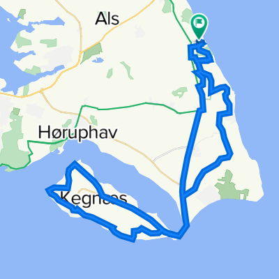
Overview
About this route
Kuperet rute som fører over det højeste punkt på Als (Høgebjerg)
Udsigstpunkter:
km 11: Høgebjerg
km 19: Ertebjerghav
km 22: Svennesmølle
Før musen hen over højdekurven for at se kilometerpunkter.
- -:--
- Duration
- 48.1 km
- Distance
- 276 m
- Ascent
- 273 m
- Descent
- ---
- Avg. speed
- 63 m
- Avg. speed
Route quality
Waytypes & surfaces along the route
Waytypes
Quiet road
39.3 km
(82 %)
Road
8.2 km
(17 %)
Surfaces
Paved
48 km
(100 %)
Asphalt
48 km
(100 %)
Undefined
0.2 km
(<1 %)
Continue with Bikemap
Use, edit, or download this cycling route
You would like to ride Sønderborg Kommune - 48 km Augustenborg or customize it for your own trip? Here is what you can do with this Bikemap route:
Free features
- Save this route as favorite or in collections
- Copy & plan your own version of this route
- Sync your route with Garmin or Wahoo
Premium features
Free trial for 3 days, or one-time payment. More about Bikemap Premium.
- Navigate this route on iOS & Android
- Export a GPX / KML file of this route
- Create your custom printout (try it for free)
- Download this route for offline navigation
Discover more Premium features.
Get Bikemap PremiumFrom our community
Other popular routes starting in Augustenborg
 Stavensbølgade 2A, Augustenborg to Mariegade 6, Sønderborg
- Distance
- 76.2 km
- Ascent
- 392 m
- Descent
- 390 m
- Location
- Augustenborg, Region South Denmark, Denmark
 South Als without Kegnæs
- Distance
- 38.4 km
- Ascent
- 188 m
- Descent
- 191 m
- Location
- Augustenborg, Region South Denmark, Denmark
 Sønderborg Kommune - 48 km Augustenborg CLONED FROM ROUTE 352909
- Distance
- 33.6 km
- Ascent
- 117 m
- Descent
- 119 m
- Location
- Augustenborg, Region South Denmark, Denmark
 D10 - Asserballeskov - Rudkøbing
- Distance
- 84.5 km
- Ascent
- 154 m
- Descent
- 181 m
- Location
- Augustenborg, Region South Denmark, Denmark
 Augustenborg-Sönderborg
- Distance
- 21.6 km
- Ascent
- 89 m
- Descent
- 85 m
- Location
- Augustenborg, Region South Denmark, Denmark
 Ketting Kegnæs rundt
- Distance
- 54.4 km
- Ascent
- 200 m
- Descent
- 198 m
- Location
- Augustenborg, Region South Denmark, Denmark
 Midt Als Rundt
- Distance
- 25.9 km
- Ascent
- 124 m
- Descent
- 122 m
- Location
- Augustenborg, Region South Denmark, Denmark
 ketting-stevning
- Distance
- 26.2 km
- Ascent
- 525 m
- Descent
- 564 m
- Location
- Augustenborg, Region South Denmark, Denmark
Open it in the app