

RDE 2016 - MTB-Herausforderung Dresdner Süden
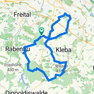
A cycling route starting in Bannewitz, Saxony, Germany.
Overview
About this route
Fahrtzeit: je nach Kondition 5-6h konditionelle Anforderung: mittel-hoch technischer Anspruch: leicht bis mittel; meist S0-S1 (kurze Abschnitte im Bereich S2)
RDE = Route des Erwin; Nach 1,5 Jahren Suche, Probefahren und Anpassung konnte eine Route zusammengestellt werden, die fast ausschließlich auf Wald- und Wanderwegen unterwegs ist. Nur selten müssen wir Straßen statt Trails benutzen.
Die konditionelle Anforderung der Strecke ist recht hoch. Wer die mitbringt, erlebt Dresdens Süden mit Gebergrund, Lockwitzgrund, der Gegend zwischen Burgstädtel, Dohna und Schlottwitz als Wendepunkt.
E-Bike-Hinweis: Spätestens in Schlottwitz (43 km) mussten wir über das Müglitztal zurückrollen, weil der Akku leer war. Entweder war er schon ganz leer oder reichte noch auf kleinster Stufe bis zur Elbe.
Aus dem Müglitztal heraus und dann noch einmal aus dem Lockwitzgrund gibt es so richtig eins in die Beine. Hier könnt ihr zeigen, ob ihr es drauf habt.
Insgesamt eine sehr schöne Mountainbike-Tour durch Dresdens Süden mit vielen schönen Aussichten, Abwechslung und schönen Singletrails.
Wir freuen uns über kurze Kommentare und wünschen gute Fahrt.
- -:--
- Duration
- 67.7 km
- Distance
- 833 m
- Ascent
- 833 m
- Descent
- ---
- Avg. speed
- ---
- Avg. speed

Route highlights
Points of interest along the route
Point of interest after 21.3 km
Denkmal und Wahrzeichen der RDE: "Das Feuer der auf Achtung gegruindeten Freundschaft erloescht nie."
Point of interest after 32.9 km
Kaiserstüb'l Weesenstein - Eis & Kuchen - kurze Stärkung für die kommenden Anstiege.
Point of interest after 46.6 km
Softeisstand zur Stärkung vor dem nächsten Anstieg
Continue with Bikemap
Use, edit, or download this cycling route
You would like to ride RDE 2016 - MTB-Herausforderung Dresdner Süden or customize it for your own trip? Here is what you can do with this Bikemap route:
Free features
- Save this route as favorite or in collections
- Copy & plan your own version of this route
- Sync your route with Garmin or Wahoo
Premium features
Free trial for 3 days, or one-time payment. More about Bikemap Premium.
- Navigate this route on iOS & Android
- Export a GPX / KML file of this route
- Create your custom printout (try it for free)
- Download this route for offline navigation
Discover more Premium features.
Get Bikemap PremiumFrom our community
Other popular routes starting in Bannewitz
 MTB Tour Windberg, Heidemühle, Wilisch, Windberg CLONED FROM ROUTE 182971
- Distance
- 42.5 km
- Ascent
- 628 m
- Descent
- 662 m
- Location
- Bannewitz, Saxony, Germany
 Vonovia-Tour
- Distance
- 28.8 km
- Ascent
- 121 m
- Descent
- 121 m
- Location
- Bannewitz, Saxony, Germany
 Etapa 046C (Dresden - Děčín)
- Distance
- 91.8 km
- Ascent
- 869 m
- Descent
- 860 m
- Location
- Bannewitz, Saxony, Germany
 Radtour Elberadweg
- Distance
- 30.6 km
- Ascent
- 26 m
- Descent
- 32 m
- Location
- Bannewitz, Saxony, Germany
 Südhöhe - Rundfahrt
- Distance
- 53.5 km
- Ascent
- 792 m
- Descent
- 747 m
- Location
- Bannewitz, Saxony, Germany
 kleine Sonntagsrunde
- Distance
- 23 km
- Ascent
- 337 m
- Descent
- 245 m
- Location
- Bannewitz, Saxony, Germany
 Bannewitz - Klingenberg - Malter - Bannewitz
- Distance
- 67.7 km
- Ascent
- 779 m
- Descent
- 727 m
- Location
- Bannewitz, Saxony, Germany
 Windberg-Poisenwald-Tharandt
- Distance
- 47.2 km
- Ascent
- 865 m
- Descent
- 865 m
- Location
- Bannewitz, Saxony, Germany
Open it in the app