
Winterwandern auf der Hochheide
A cycling route starting in Willingen, Hesse, Germany.
Overview
About this route
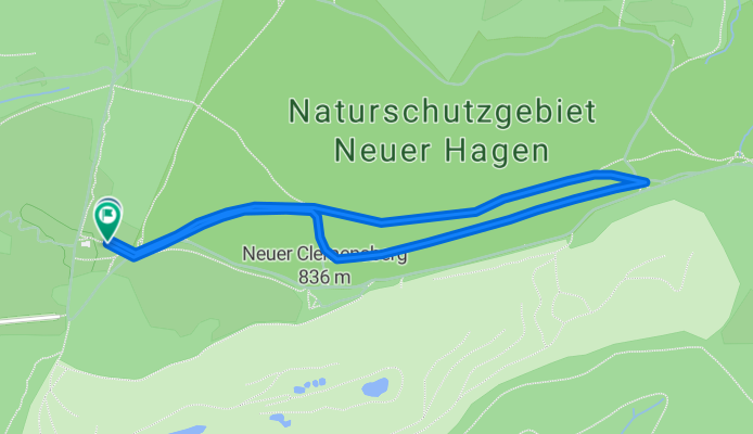
Rundtour durch das Naturschutzgebiet Hoher Hagen mit aussichtsreichen Abstecher auf den Clemensberg. Von der Hochheide-Hütte geht es über das Naturschutzgebiet Hoher Hagen auf der hochheide Richtung Hoppecke Quelle. Stoßen Sie auf den Rothaarsteig rechts abbiegen und am Rande der Hochheide vorbei am Clemensberg, auf den ein Abstecher mit Panoramablick lohnenswert ist, zurück zum Ausgangspunkt.
- -:--
- Duration
- 2.7 km
- Distance
- 41 m
- Ascent
- 39 m
- Descent
- ---
- Avg. speed
- ---
- Avg. speed
Continue with Bikemap
Use, edit, or download this cycling route
You would like to ride Winterwandern auf der Hochheide or customize it for your own trip? Here is what you can do with this Bikemap route:
Free features
- Save this route as favorite or in collections
- Copy & plan your own version of this route
- Sync your route with Garmin or Wahoo
Premium features
Free trial for 3 days, or one-time payment. More about Bikemap Premium.
- Navigate this route on iOS & Android
- Export a GPX / KML file of this route
- Create your custom printout (try it for free)
- Download this route for offline navigation
Discover more Premium features.
Get Bikemap PremiumFrom our community
Other popular routes starting in Willingen
 Diemelseerunde im Uhrzeigersinn inkl. Muffert
- Distance
- 35.7 km
- Ascent
- 659 m
- Descent
- 661 m
- Location
- Willingen, Hesse, Germany
 FELT Coffee ride
- Distance
- 28 km
- Ascent
- 561 m
- Descent
- 557 m
- Location
- Willingen, Hesse, Germany
 Ottlar - Rattlar - Schwalefeld und zurück
- Distance
- 27.4 km
- Ascent
- 437 m
- Descent
- 435 m
- Location
- Willingen, Hesse, Germany
 Rattlar - Diemelsee - Rattlar
- Distance
- 25.1 km
- Ascent
- 327 m
- Descent
- 327 m
- Location
- Willingen, Hesse, Germany
 Granzkamm Trail
- Distance
- 40 km
- Ascent
- 871 m
- Descent
- 871 m
- Location
- Willingen, Hesse, Germany
 Hochplateau Runde
- Distance
- 61 km
- Ascent
- 1,332 m
- Descent
- 1,332 m
- Location
- Willingen, Hesse, Germany
 Willingen 2010 kurz
- Distance
- 51.6 km
- Ascent
- 1,257 m
- Descent
- 1,257 m
- Location
- Willingen, Hesse, Germany
 Willinger Bergrunde
- Distance
- 97.1 km
- Ascent
- 990 m
- Descent
- 990 m
- Location
- Willingen, Hesse, Germany
Open it in the app