

SanTeo
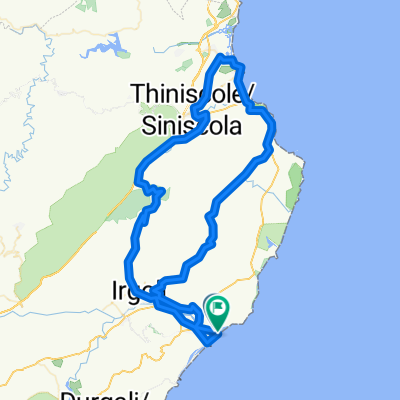
A cycling route starting in Orosei, Sardinia, Italy.
Overview
About this route
Was ist Bikemap?
Finde und suche Routen
Erstelle eine Route
Exportiere und teile Routen
Alle Fragen
Abbrechen
uzahne uzahne
Home
Routes
Regions
Apps
Help
Willkommen im Routen Editor
Bike Paths
Heatmap
Relief Map ▼
Distance: 139.97 km, Altitude: 1580 hm
5 km
3 mi
km
hm
0
30
60
90
120
0
300
600
Leaflet | © Toursprung GmbH - © Map Data: OSM Contributors - Improve this map
Neue Route erstellen
Title image
Füge ein Titelbild zu deiner Route hinzu
Routentitel *
Bitte gib einen Titel für die Route ein.
Beschreibung
◢
GPX oder KML Datei hochladen
Ziehe eine GPX / KML-Datei hier hinein und klicke auf hochladen.
- -:--
- Duration
- 140 km
- Distance
- 1,192 m
- Ascent
- 1,193 m
- Descent
- ---
- Avg. speed
- ---
- Avg. speed
Route quality
Waytypes & surfaces along the route
Waytypes
Busy road
71 km
(51 %)
Road
29.5 km
(21 %)
Surfaces
Paved
82.8 km
(59 %)
Unpaved
12.3 km
(9 %)
Asphalt
82.8 km
(59 %)
Ground
8.9 km
(6 %)
Continue with Bikemap
Use, edit, or download this cycling route
You would like to ride SanTeo or customize it for your own trip? Here is what you can do with this Bikemap route:
Free features
- Save this route as favorite or in collections
- Copy & plan your own version of this route
- Sync your route with Garmin or Wahoo
Premium features
Free trial for 3 days, or one-time payment. More about Bikemap Premium.
- Navigate this route on iOS & Android
- Export a GPX / KML file of this route
- Create your custom printout (try it for free)
- Download this route for offline navigation
Discover more Premium features.
Get Bikemap PremiumFrom our community
Other popular routes starting in Orosei
 Sardinien 2012-1; Um den weissen Berg
- Distance
- 124.1 km
- Ascent
- 1,369 m
- Descent
- 1,371 m
- Location
- Orosei, Sardinia, Italy
 Sardinien: Orosei - Prolog
- Distance
- 54.4 km
- Ascent
- 684 m
- Descent
- 662 m
- Location
- Orosei, Sardinia, Italy
 Sardinien 2012-4; In den einsamen Bergen
- Distance
- 76.8 km
- Ascent
- 1,135 m
- Descent
- 1,135 m
- Location
- Orosei, Sardinia, Italy
 Orosei-Onofai-Capo Camino-Orosei
- Distance
- 56.4 km
- Ascent
- 651 m
- Descent
- 646 m
- Location
- Orosei, Sardinia, Italy
 Sardinien: Siniscola, Dorgali
- Distance
- 98.2 km
- Ascent
- 1,227 m
- Descent
- 1,085 m
- Location
- Orosei, Sardinia, Italy
 OROSEI kleine aber feine Hinterlandtour
- Distance
- 34.4 km
- Ascent
- 323 m
- Descent
- 327 m
- Location
- Orosei, Sardinia, Italy
 Route_1_2018_Auftakt_Orosei_Dorgali_Irgoli_Galtelli_Orosei
- Distance
- 62.3 km
- Ascent
- 551 m
- Descent
- 553 m
- Location
- Orosei, Sardinia, Italy
 Sardinien 2012-7; San Giovanni
- Distance
- 94.7 km
- Ascent
- 1,006 m
- Descent
- 1,005 m
- Location
- Orosei, Sardinia, Italy
Open it in the app