
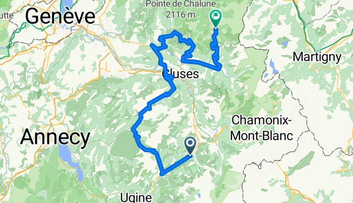
Tour de France 2016 Stage 20: 146 km Megève - Morzin
A cycling route starting in Megève, Auvergne-Rhône-Alpes, France.
Overview
About this route
{Saturday, 23 July}
On the day before Paris, the peloton is still in the Alps going for the very last mountain stage. After the four impressive climbs of the day, will the race be decided on Col de Joux-Plane and the difficult descent into Morzine?
{Samstag, 23. Juli}
Am Tag vor Paris kämpft das Peloton noch um die letzte Bergetappe in den Alpen. Wird sich das Rennen ach vier schweren Anstiegen am Col de Joux-Plane oder während der anspruchsvollen Abfahrt nach Morzine entscheiden?
All Stages / Etappenübersicht
- -:--
- Duration
- 150.2 km
- Distance
- 3,296 m
- Ascent
- 3,400 m
- Descent
- ---
- Avg. speed
- ---
- Avg. speed

Route quality
Waytypes & surfaces along the route
Waytypes
Busy road
83.1 km
(55 %)
Road
51.6 km
(34 %)
Surfaces
Paved
119.5 km
(80 %)
Unpaved
0.5 km
(<1 %)
Asphalt
118.8 km
(79 %)
Paved (undefined)
0.6 km
(<1 %)
Continue with Bikemap
Use, edit, or download this cycling route
You would like to ride Tour de France 2016 Stage 20: 146 km Megève - Morzin or customize it for your own trip? Here is what you can do with this Bikemap route:
Free features
- Save this route as favorite or in collections
- Copy & plan your own version of this route
- Sync your route with Garmin or Wahoo
Premium features
Free trial for 3 days, or one-time payment. More about Bikemap Premium.
- Navigate this route on iOS & Android
- Export a GPX / KML file of this route
- Create your custom printout (try it for free)
- Download this route for offline navigation
Discover more Premium features.
Get Bikemap PremiumFrom our community
Other popular routes starting in Megève
 Tour de France 2016 - Stage 20
- Distance
- 150.9 km
- Ascent
- 3,259 m
- Descent
- 3,365 m
- Location
- Megève, Auvergne-Rhône-Alpes, France
 Col Hunting Le Beaufortain
- Distance
- 74.1 km
- Ascent
- 1,795 m
- Descent
- 1,795 m
- Location
- Megève, Auvergne-Rhône-Alpes, France
 Megève 22km jour 1
- Distance
- 22.6 km
- Ascent
- 1,171 m
- Descent
- 1,158 m
- Location
- Megève, Auvergne-Rhône-Alpes, France
 Stäfa - Tarifa Stage #4 Megève - St. Michel de Maurienne
- Distance
- 108.2 km
- Ascent
- 556 m
- Descent
- 927 m
- Location
- Megève, Auvergne-Rhône-Alpes, France
 De Place de la Résistance, Megève à 290 Route du Palais des Sports, Megève
- Distance
- 14.4 km
- Ascent
- 420 m
- Descent
- 422 m
- Location
- Megève, Auvergne-Rhône-Alpes, France
 Col des Aravis from Megeve
- Distance
- 42.7 km
- Ascent
- 847 m
- Descent
- 845 m
- Location
- Megève, Auvergne-Rhône-Alpes, France
 Chamonix222
- Distance
- 41.1 km
- Ascent
- 681 m
- Descent
- 752 m
- Location
- Megève, Auvergne-Rhône-Alpes, France
 Col des Aravis from Megeve
- Distance
- 42.7 km
- Ascent
- 874 m
- Descent
- 870 m
- Location
- Megève, Auvergne-Rhône-Alpes, France
Open it in the app