

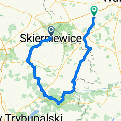
Arkadia - Nieborów - Droga Łowicka (szlaki rowerowe)
A cycling route starting in Skierniewice, Łódź Voivodeship, Poland.
Overview
About this route
- -:--
- Duration
- 43 km
- Distance
- 62 m
- Ascent
- 61 m
- Descent
- ---
- Avg. speed
- ---
- Avg. speed

Route quality
Waytypes & surfaces along the route
Waytypes
Quiet road
17.9 km
(42 %)
Road
16.2 km
(38 %)
Surfaces
Paved
26.5 km
(62 %)
Unpaved
11 km
(26 %)
Asphalt
24.4 km
(57 %)
Gravel
5.1 km
(12 %)
Continue with Bikemap
Use, edit, or download this cycling route
You would like to ride Arkadia - Nieborów - Droga Łowicka (szlaki rowerowe) or customize it for your own trip? Here is what you can do with this Bikemap route:
Free features
- Save this route as favorite or in collections
- Copy & plan your own version of this route
- Sync your route with Garmin or Wahoo
Premium features
Free trial for 3 days, or one-time payment. More about Bikemap Premium.
- Navigate this route on iOS & Android
- Export a GPX / KML file of this route
- Create your custom printout (try it for free)
- Download this route for offline navigation
Discover more Premium features.
Get Bikemap PremiumFrom our community
Other popular routes starting in Skierniewice
 Tour de Baby
- Distance
- 103.2 km
- Ascent
- 234 m
- Descent
- 157 m
- Location
- Skierniewice, Łódź Voivodeship, Poland
 Skierniewice Bolimów Zadębie
- Distance
- 68.2 km
- Ascent
- 66 m
- Descent
- 69 m
- Location
- Skierniewice, Łódź Voivodeship, Poland
 Budy Grabskie 50B, Skierniewice to Budy Grabskie, Skierniewice
- Distance
- 68.7 km
- Ascent
- 229 m
- Descent
- 213 m
- Location
- Skierniewice, Łódź Voivodeship, Poland
 Pierwsza czerwcowa niedziela
- Distance
- 41.2 km
- Ascent
- 43 m
- Descent
- 43 m
- Location
- Skierniewice, Łódź Voivodeship, Poland
 Skierniewice-Las Łagiewnicki
- Distance
- 95.2 km
- Ascent
- 375 m
- Descent
- 251 m
- Location
- Skierniewice, Łódź Voivodeship, Poland
 Rozpoczęcie sezonu 2013
- Distance
- 48.3 km
- Ascent
- 79 m
- Descent
- 76 m
- Location
- Skierniewice, Łódź Voivodeship, Poland
 Mój BikeOrient 2012
- Distance
- 50.7 km
- Ascent
- 114 m
- Descent
- 116 m
- Location
- Skierniewice, Łódź Voivodeship, Poland
 2014-03-29.30_Skierniewice - Bunkier w Konewce
- Distance
- 181.7 km
- Ascent
- 337 m
- Descent
- 356 m
- Location
- Skierniewice, Łódź Voivodeship, Poland
Open it in the app