

St Ninian's Way- Barrhill to Colmonell
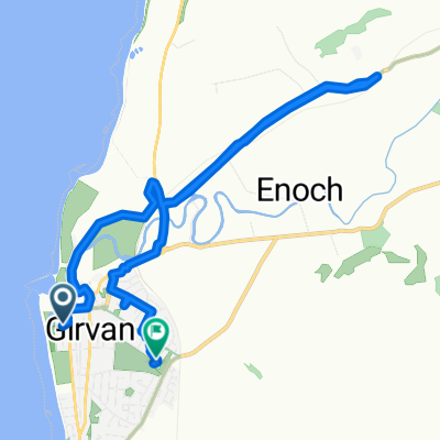
A cycling route starting in Girvan, Scotland, United Kingdom.
Overview
About this route
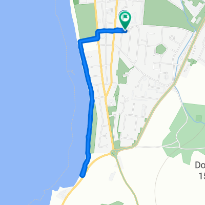
Barrhill to Colmonell.
This 17th section of St Ninian’s Way starts from Barrhill and, crossing the A714, goes north for 300m to the bridge over the Duisk River. Cross bridge and turn left along wood and, keeping the river on your left, arrive at Belhamage (3 km). Take track to north-west to join minor road (1 km) and continue along road and track to Liglartrie (1 km) . Go north-east along minor road to Pinwherry (2 km). Turn left, south, along A714, cross bridge and proceed another 300 m to meet bridge under railway line. Go under bridge and west along path with the River Stinchar to north to arrive at crossroads (5 km) . Turn right , cross bridge and arrive in Colmonell (1 Km).
Undulating tracks along river valleys .
Also part of the Whithorn Way - http://www.whithornway.org . courtesy of the WWSG where a detailed route description with grid references is available.
For a map overview of Part 1 and Part 2 of St Ninian’s Way please go to https://www.bikemap.net/en/route/3548129-st-ninians-way-carlisle-to-st-andrews-part-1-carlisle-to-whithorn/
St Ninian’s Way is one of the great pilgrim routes in Scotland to St Andrews - The Way of St Andrews - For other routes see http://www.thewayofstandrews.com
- -:--
- Duration
- 12.7 km
- Distance
- 165 m
- Ascent
- 197 m
- Descent
- ---
- Avg. speed
- ---
- Avg. speed

Continue with Bikemap
Use, edit, or download this cycling route
You would like to ride St Ninian's Way- Barrhill to Colmonell or customize it for your own trip? Here is what you can do with this Bikemap route:
Free features
- Save this route as favorite or in collections
- Copy & plan your own version of this route
- Sync your route with Garmin or Wahoo
Premium features
Free trial for 3 days, or one-time payment. More about Bikemap Premium.
- Navigate this route on iOS & Android
- Export a GPX / KML file of this route
- Create your custom printout (try it for free)
- Download this route for offline navigation
Discover more Premium features.
Get Bikemap PremiumFrom our community
Other popular routes starting in Girvan
 Old Daily - Maybole circuit
- Distance
- 58.7 km
- Ascent
- 550 m
- Descent
- 552 m
- Location
- Girvan, Scotland, United Kingdom
 Girvan and South Carrick Ward, Girvan to Girvan and South Carrick Ward, Girvan
- Distance
- 28.3 km
- Ascent
- 339 m
- Descent
- 339 m
- Location
- Girvan, Scotland, United Kingdom
 Hervey Road 1 to The Clachan 36, Barr
- Distance
- 13.7 km
- Ascent
- 288 m
- Descent
- 188 m
- Location
- Girvan, Scotland, United Kingdom
 Hervey Road 1 to Hervey Road 1
- Distance
- 3.3 km
- Ascent
- 66 m
- Descent
- 58 m
- Location
- Girvan, Scotland, United Kingdom
 Sophie and emma
- Distance
- 10.1 km
- Ascent
- 230 m
- Descent
- 219 m
- Location
- Girvan, Scotland, United Kingdom
 15 Back Road, Girvan to 47 Main Street, Girvan
- Distance
- 99.8 km
- Ascent
- 963 m
- Descent
- 971 m
- Location
- Girvan, Scotland, United Kingdom
 11 Back Road, Girvan to 47 Main Street, Girvan
- Distance
- 23.9 km
- Ascent
- 488 m
- Descent
- 496 m
- Location
- Girvan, Scotland, United Kingdom
 Barr / Pinmore Loop (above Girvan)
- Distance
- 27.9 km
- Ascent
- 316 m
- Descent
- 317 m
- Location
- Girvan, Scotland, United Kingdom
Open it in the app