

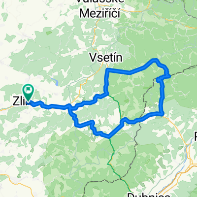
AVION TRIP I. Zlin-Tecovice-Chlum-Rozhledna Hostisova-Chlum-Zlin
A cycling route starting in Zlín, Zlín, Czechia.
Overview
About this route
Zlín-Tečovice-Chlum-Rozhledna Hostišová-Chlum-Zlín
- -:--
- Duration
- 26.5 km
- Distance
- 254 m
- Ascent
- 264 m
- Descent
- ---
- Avg. speed
- ---
- Avg. speed

Route quality
Waytypes & surfaces along the route
Waytypes
Quiet road
12.5 km
(47 %)
Track
3.9 km
(15 %)
Surfaces
Paved
11.4 km
(43 %)
Unpaved
2.6 km
(10 %)
Asphalt
9 km
(34 %)
Ground
2 km
(8 %)
Continue with Bikemap
Use, edit, or download this cycling route
You would like to ride AVION TRIP I. Zlin-Tecovice-Chlum-Rozhledna Hostisova-Chlum-Zlin or customize it for your own trip? Here is what you can do with this Bikemap route:
Free features
- Save this route as favorite or in collections
- Copy & plan your own version of this route
- Sync your route with Garmin or Wahoo
Premium features
Free trial for 3 days, or one-time payment. More about Bikemap Premium.
- Navigate this route on iOS & Android
- Export a GPX / KML file of this route
- Create your custom printout (try it for free)
- Download this route for offline navigation
Discover more Premium features.
Get Bikemap PremiumFrom our community
Other popular routes starting in Zlín
 Kaprův okruh - kolem Pinduly
- Distance
- 17.4 km
- Ascent
- 470 m
- Descent
- 471 m
- Location
- Zlín, Zlín, Czechia
 _CZE _ Hostýnské vrchy - Zlín - Racková - Rusava - Lukov - Velíková - Zlín
- Distance
- 49.9 km
- Ascent
- 745 m
- Descent
- 745 m
- Location
- Zlín, Zlín, Czechia
 jaroslavice - pindula - želechovice
- Distance
- 15.6 km
- Ascent
- 349 m
- Descent
- 336 m
- Location
- Zlín, Zlín, Czechia
 Svatá voda přes Maják
- Distance
- 23.7 km
- Ascent
- 436 m
- Descent
- 439 m
- Location
- Zlín, Zlín, Czechia
 Zlín - Lysá hora
- Distance
- 111.7 km
- Ascent
- 1,970 m
- Descent
- 879 m
- Location
- Zlín, Zlín, Czechia
 Kocanda Chlum
- Distance
- 19.5 km
- Ascent
- 292 m
- Descent
- 292 m
- Location
- Zlín, Zlín, Czechia
 Nedělní pohodička
- Distance
- 30.8 km
- Ascent
- 50 m
- Descent
- 139 m
- Location
- Zlín, Zlín, Czechia
 Zlín - Portáš
- Distance
- 129.3 km
- Ascent
- 1,272 m
- Descent
- 1,272 m
- Location
- Zlín, Zlín, Czechia
Open it in the app