

LAGARTIJAS BIKE RACE 15K - 30K
A cycling route starting in Sangolquí, Provincia de Pichincha, Ecuador.
Overview
About this route
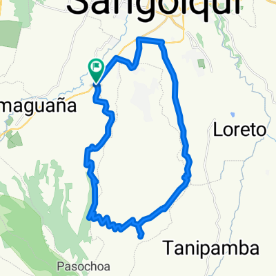
Es una competencia de ciclismo de montaña que se desarrolla en caminos de segundo orden, empedrado, tierra, pasto y ripio en un circuito marcado y diseñado específicamente para este evento, con distancias de 15k y 30k. Esta prueba busca que tanto las deportistas élites como los amateur disfruten de la naturaleza y todo lo que su entorno puede ofrecer, y esta es la tercera edición y será en el Parque Metropolitano del Sur.
- -:--
- Duration
- 15.6 km
- Distance
- 608 m
- Ascent
- 609 m
- Descent
- ---
- Avg. speed
- ---
- Avg. speed

Route photos


Continue with Bikemap
Use, edit, or download this cycling route
You would like to ride LAGARTIJAS BIKE RACE 15K - 30K or customize it for your own trip? Here is what you can do with this Bikemap route:
Free features
- Save this route as favorite or in collections
- Copy & plan your own version of this route
- Sync your route with Garmin or Wahoo
Premium features
Free trial for 3 days, or one-time payment. More about Bikemap Premium.
- Navigate this route on iOS & Android
- Export a GPX / KML file of this route
- Create your custom printout (try it for free)
- Download this route for offline navigation
Discover more Premium features.
Get Bikemap PremiumFrom our community
Other popular routes starting in Sangolquí
 entrada a cotogchoa
- Distance
- 23.5 km
- Ascent
- 424 m
- Descent
- 427 m
- Location
- Sangolquí, Provincia de Pichincha, Ecuador
 Route to "La Carolina"
- Distance
- 24 km
- Ascent
- 197 m
- Descent
- 551 m
- Location
- Sangolquí, Provincia de Pichincha, Ecuador
 Descubriendo Conocoto II
- Distance
- 13.1 km
- Ascent
- 346 m
- Descent
- 351 m
- Location
- Sangolquí, Provincia de Pichincha, Ecuador
 RUTA DE LOS VOLCANES
- Distance
- 37.8 km
- Ascent
- 1,781 m
- Descent
- 612 m
- Location
- Sangolquí, Provincia de Pichincha, Ecuador
 Río Pita
- Distance
- 38.7 km
- Ascent
- 0 m
- Descent
- 0 m
- Location
- Sangolquí, Provincia de Pichincha, Ecuador
 parque
- Distance
- 17.5 km
- Ascent
- 582 m
- Descent
- 550 m
- Location
- Sangolquí, Provincia de Pichincha, Ecuador
 cashapamba alto
- Distance
- 29.7 km
- Ascent
- 462 m
- Descent
- 437 m
- Location
- Sangolquí, Provincia de Pichincha, Ecuador
 Amaguaña - Pasochoa 2011
- Distance
- 32.9 km
- Ascent
- 913 m
- Descent
- 913 m
- Location
- Sangolquí, Provincia de Pichincha, Ecuador
Open it in the app