

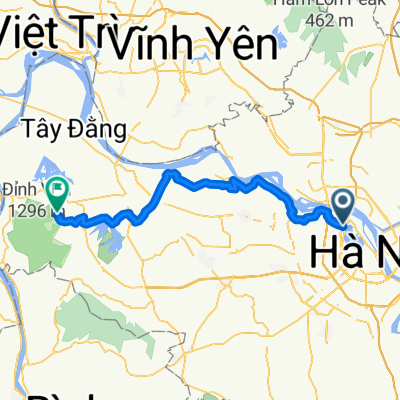
CPTRA to TamDao via DaiLai
A cycling route starting in Tây Hồ, Thành Phố Hà Nội, Vietnam.
Overview
About this route
- -:--
- Duration
- 60.7 km
- Distance
- 979 m
- Ascent
- 72 m
- Descent
- ---
- Avg. speed
- ---
- Avg. speed

Continue with Bikemap
Use, edit, or download this cycling route
You would like to ride CPTRA to TamDao via DaiLai or customize it for your own trip? Here is what you can do with this Bikemap route:
Free features
- Save this route as favorite or in collections
- Copy & plan your own version of this route
- Sync your route with Garmin or Wahoo
Premium features
Free trial for 3 days, or one-time payment. More about Bikemap Premium.
- Navigate this route on iOS & Android
- Export a GPX / KML file of this route
- Create your custom printout (try it for free)
- Download this route for offline navigation
Discover more Premium features.
Get Bikemap PremiumFrom our community
Other popular routes starting in Tây Hồ
 Hanoi - SocSon - PhoYen - Dai Lai - Hanoi
- Distance
- 105.3 km
- Ascent
- 142 m
- Descent
- 140 m
- Location
- Tây Hồ, Thành Phố Hà Nội, Vietnam
 finish
- Distance
- 14.9 km
- Ascent
- 154 m
- Descent
- 130 m
- Location
- Tây Hồ, Thành Phố Hà Nội, Vietnam
 Tamdao Rote
- Distance
- 66.7 km
- Ascent
- 1,010 m
- Descent
- 89 m
- Location
- Tây Hồ, Thành Phố Hà Nội, Vietnam
 杉澤さん送別ライド
- Distance
- 84.7 km
- Ascent
- 113 m
- Descent
- 113 m
- Location
- Tây Hồ, Thành Phố Hà Nội, Vietnam
 Hanoi to Ba Vi National Park
- Distance
- 115 km
- Ascent
- 1,199 m
- Descent
- 1,265 m
- Location
- Tây Hồ, Thành Phố Hà Nội, Vietnam
 Day 1_Hanoi to Ba Vi Homestead
- Distance
- 63.8 km
- Ascent
- 109 m
- Descent
- 56 m
- Location
- Tây Hồ, Thành Phố Hà Nội, Vietnam
 Grand route in dream
- Distance
- 4,375.8 km
- Ascent
- 14,108 m
- Descent
- 10,283 m
- Location
- Tây Hồ, Thành Phố Hà Nội, Vietnam
 Thuê xe máy tại Đống Đa: Cách kiểm tra trước khi sử dụng
- Distance
- 10.1 km
- Ascent
- 60 m
- Descent
- 58 m
- Location
- Tây Hồ, Thành Phố Hà Nội, Vietnam
Open it in the app