

Lange Radrunde vom 10.08.16 17:58
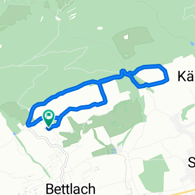
A cycling route starting in Bettlach, Canton of Solothurn, Switzerland.
Overview
About this route
- -:--
- Duration
- 60.9 km
- Distance
- 109 m
- Ascent
- 312 m
- Descent
- ---
- Avg. speed
- ---
- Avg. speed

Route quality
Waytypes & surfaces along the route
Waytypes
Quiet road
24.2 km
(40 %)
Track
13.9 km
(23 %)
Surfaces
Paved
36.9 km
(61 %)
Unpaved
13.4 km
(22 %)
Asphalt
34.6 km
(57 %)
Gravel
11.1 km
(18 %)
Route highlights
Points of interest along the route

Point of interest after 23.5 km
Wangen a Aare

Point of interest after 23.5 km
Wangen a Aare
Continue with Bikemap
Use, edit, or download this cycling route
You would like to ride Lange Radrunde vom 10.08.16 17:58 or customize it for your own trip? Here is what you can do with this Bikemap route:
Free features
- Save this route as favorite or in collections
- Copy & plan your own version of this route
- Sync your route with Garmin or Wahoo
Premium features
Free trial for 3 days, or one-time payment. More about Bikemap Premium.
- Navigate this route on iOS & Android
- Export a GPX / KML file of this route
- Create your custom printout (try it for free)
- Download this route for offline navigation
Discover more Premium features.
Get Bikemap PremiumFrom our community
Other popular routes starting in Bettlach
 Bucheggberg Route
- Distance
- 115.9 km
- Ascent
- 795 m
- Descent
- 833 m
- Location
- Bettlach, Canton of Solothurn, Switzerland
 Kurze Ausfahrt vom 22.07.16 19:23
- Distance
- 6.5 km
- Ascent
- 149 m
- Descent
- 148 m
- Location
- Bettlach, Canton of Solothurn, Switzerland
 Ausfahrt vom 09.09.16 19:53
- Distance
- 20.4 km
- Ascent
- 671 m
- Descent
- 671 m
- Location
- Bettlach, Canton of Solothurn, Switzerland
 Ausfahrt vom 15.08.16 19:00
- Distance
- 10.1 km
- Ascent
- 286 m
- Descent
- 313 m
- Location
- Bettlach, Canton of Solothurn, Switzerland
 2.2.Tour La Huette über Jobert, Walberg nach Gleresse
- Distance
- 38.1 km
- Ascent
- 1,024 m
- Descent
- 1,137 m
- Location
- Bettlach, Canton of Solothurn, Switzerland
 Route in Bettlach
- Distance
- 57.8 km
- Ascent
- 536 m
- Descent
- 534 m
- Location
- Bettlach, Canton of Solothurn, Switzerland
 Bettlachberg nach Grotweg 11, Lengnau
- Distance
- 7.6 km
- Ascent
- 34 m
- Descent
- 237 m
- Location
- Bettlach, Canton of Solothurn, Switzerland
 Bettlachberg nach Grenchen, Bettlachrank
- Distance
- 2 km
- Ascent
- 429 m
- Descent
- 60 m
- Location
- Bettlach, Canton of Solothurn, Switzerland
Open it in the app