

Assietta day 2
A cycling route starting in Usseaux, Piedmont, Italy.
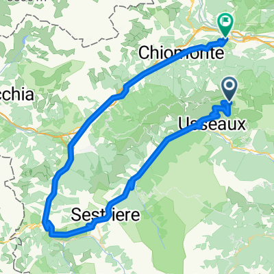
Overview
About this route
- -:--
- Duration
- 65.1 km
- Distance
- 1,811 m
- Ascent
- 1,812 m
- Descent
- ---
- Avg. speed
- ---
- Avg. speed

Continue with Bikemap
Use, edit, or download this cycling route
You would like to ride Assietta day 2 or customize it for your own trip? Here is what you can do with this Bikemap route:
Free features
- Save this route as favorite or in collections
- Copy & plan your own version of this route
- Sync your route with Garmin or Wahoo
Premium features
Free trial for 3 days, or one-time payment. More about Bikemap Premium.
- Navigate this route on iOS & Android
- Export a GPX / KML file of this route
- Create your custom printout (try it for free)
- Download this route for offline navigation
Discover more Premium features.
Get Bikemap PremiumFrom our community
Other popular routes starting in Usseaux
 Tour du grand serein
- Distance
- 36.8 km
- Ascent
- 1,096 m
- Descent
- 1,970 m
- Location
- Usseaux, Piedmont, Italy
 Gran Tour dell'Assietta
- Distance
- 61.8 km
- Ascent
- 2,201 m
- Descent
- 2,202 m
- Location
- Usseaux, Piedmont, Italy
 Strada dell'Assietta (da Pourrieres - ritorno su asfalto)
- Distance
- 55.2 km
- Ascent
- 1,368 m
- Descent
- 1,378 m
- Location
- Usseaux, Piedmont, Italy
 Ciantiplagna
- Distance
- 61.4 km
- Ascent
- 1,769 m
- Descent
- 1,768 m
- Location
- Usseaux, Piedmont, Italy
 2024-5CdFinestre-Straße
- Distance
- 72.8 km
- Ascent
- 967 m
- Descent
- 2,630 m
- Location
- Usseaux, Piedmont, Italy
 Usseaux - Sauze d'Oulx
- Distance
- 48 km
- Ascent
- 1,067 m
- Descent
- 1,000 m
- Location
- Usseaux, Piedmont, Italy
 Seealpen Tag 2 (Variante 1: 1.500 hm)
- Distance
- 48.6 km
- Ascent
- 1,385 m
- Descent
- 1,204 m
- Location
- Usseaux, Piedmont, Italy
 Assietta training: da Pourrier fino a cima Ciantiplagna
- Distance
- 31.5 km
- Ascent
- 1,495 m
- Descent
- 1,498 m
- Location
- Usseaux, Piedmont, Italy
Open it in the app