

progetto 1
A cycling route starting in Pinzano al Tagliamento, Friuli Venezia Giulia, Italy.
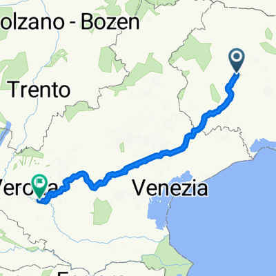
Overview
About this route
- -:--
- Duration
- 124.8 km
- Distance
- 50 m
- Ascent
- 224 m
- Descent
- ---
- Avg. speed
- ---
- Max. altitude
Route quality
Waytypes & surfaces along the route
Waytypes
Track
39.9 km
(32 %)
Quiet road
34.9 km
(28 %)
Surfaces
Paved
48.7 km
(39 %)
Unpaved
31.2 km
(25 %)
Asphalt
47.4 km
(38 %)
Gravel
18.7 km
(15 %)
Continue with Bikemap
Use, edit, or download this cycling route
You would like to ride progetto 1 or customize it for your own trip? Here is what you can do with this Bikemap route:
Free features
- Save this route as favorite or in collections
- Copy & plan your own version of this route
- Split it into stages to create a multi-day tour
- Sync your route with Garmin or Wahoo
Premium features
Free trial for 3 days, or one-time payment. More about Bikemap Premium.
- Navigate this route on iOS & Android
- Export a GPX / KML file of this route
- Create your custom printout (try it for free)
- Download this route for offline navigation
Discover more Premium features.
Get Bikemap PremiumFrom our community
Other popular routes starting in Pinzano al Tagliamento
 RR-Berg: Monte di Ragogna (Nahe Osoppo/Gemona im Tagliamento-Tal)
- Distance
- 12 km
- Ascent
- 368 m
- Descent
- 370 m
- Location
- Pinzano al Tagliamento, Friuli Venezia Giulia, Italy
 Pinzano, Clauzetto
- Distance
- 29.3 km
- Ascent
- 751 m
- Descent
- 761 m
- Location
- Pinzano al Tagliamento, Friuli Venezia Giulia, Italy
 5.1 Colle - Vassacher See + Slowenien
- Distance
- 132.3 km
- Ascent
- 1,132 m
- Descent
- 749 m
- Location
- Pinzano al Tagliamento, Friuli Venezia Giulia, Italy
 Pinzano - Verzegnis - Pinzano
- Distance
- 102.5 km
- Ascent
- 2,192 m
- Descent
- 2,192 m
- Location
- Pinzano al Tagliamento, Friuli Venezia Giulia, Italy
 Valeriano-Val Preone-Rest-Valeriano
- Distance
- 103.3 km
- Ascent
- 1,540 m
- Descent
- 1,540 m
- Location
- Pinzano al Tagliamento, Friuli Venezia Giulia, Italy
 Da Pinzano a San Daniele
- Distance
- 9.3 km
- Ascent
- 153 m
- Descent
- 102 m
- Location
- Pinzano al Tagliamento, Friuli Venezia Giulia, Italy
 Via Circonvallazione 21, Pinzano al Tagliamento nach SP 19, Zevio
- Distance
- 238.9 km
- Ascent
- 365 m
- Descent
- 530 m
- Location
- Pinzano al Tagliamento, Friuli Venezia Giulia, Italy
 Pinzano al Tagliamento - Villa Santina - Lago Dei Tramonti - Pinzano al Tagliamento
- Distance
- 115.9 km
- Ascent
- 3,699 m
- Descent
- 3,463 m
- Location
- Pinzano al Tagliamento, Friuli Venezia Giulia, Italy
Open it in the app