

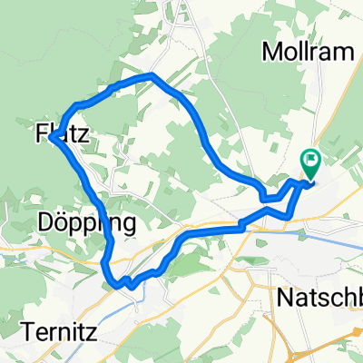
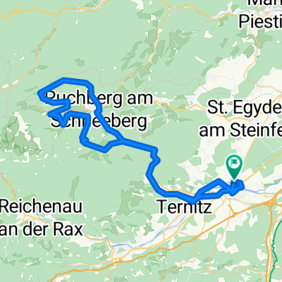
MHO Puchberg Schoberhütte
A cycling route starting in Neunkirchen, Lower Austria, Austria.
Overview
About this route
Loipersbach Mollram Grünbach Puchberg Schoberhütte Sieding Ternitz Petersberg Loipersbach
- -:--
- Duration
- 62.5 km
- Distance
- 756 m
- Ascent
- 756 m
- Descent
- ---
- Avg. speed
- ---
- Avg. speed
Route quality
Waytypes & surfaces along the route
Waytypes
Track
22.1 km
(35 %)
Quiet road
21.5 km
(34 %)
Surfaces
Paved
27.5 km
(44 %)
Unpaved
20 km
(32 %)
Asphalt
26.1 km
(42 %)
Gravel
12.4 km
(20 %)
Continue with Bikemap
Use, edit, or download this cycling route
You would like to ride MHO Puchberg Schoberhütte or customize it for your own trip? Here is what you can do with this Bikemap route:
Free features
- Save this route as favorite or in collections
- Copy & plan your own version of this route
- Sync your route with Garmin or Wahoo
Premium features
Free trial for 3 days, or one-time payment. More about Bikemap Premium.
- Navigate this route on iOS & Android
- Export a GPX / KML file of this route
- Create your custom printout (try it for free)
- Download this route for offline navigation
Discover more Premium features.
Get Bikemap PremiumFrom our community
Other popular routes starting in Neunkirchen
 Grillenberg-Strecke
- Distance
- 51.6 km
- Ascent
- 664 m
- Descent
- 660 m
- Location
- Neunkirchen, Lower Austria, Austria
 Heimatausflug 1
- Distance
- 118.4 km
- Ascent
- 1,808 m
- Descent
- 1,808 m
- Location
- Neunkirchen, Lower Austria, Austria
 Hauptplatz nach Conradplatz
- Distance
- 66.8 km
- Ascent
- 216 m
- Descent
- 460 m
- Location
- Neunkirchen, Lower Austria, Austria
 Plonnergasse 13, Neunkirchen nach Plonnergasse 11, Neunkirchen
- Distance
- 17.6 km
- Ascent
- 143 m
- Descent
- 158 m
- Location
- Neunkirchen, Lower Austria, Austria
 Hausrunde
- Distance
- 43.7 km
- Ascent
- 466 m
- Descent
- 437 m
- Location
- Neunkirchen, Lower Austria, Austria
 Schneebergrunde
- Distance
- 68.9 km
- Ascent
- 881 m
- Descent
- 881 m
- Location
- Neunkirchen, Lower Austria, Austria
 St.Corona Runde und bromberg
- Distance
- 77.8 km
- Ascent
- 1,150 m
- Descent
- 1,153 m
- Location
- Neunkirchen, Lower Austria, Austria
 Lichtenegg-Runde 1
- Distance
- 65.2 km
- Ascent
- 882 m
- Descent
- 879 m
- Location
- Neunkirchen, Lower Austria, Austria
Open it in the app