

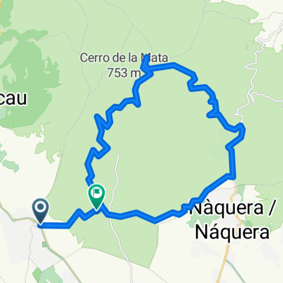
alto romero
A cycling route starting in Olocau, Valencia, Spain.
Overview
About this route
- -:--
- Duration
- 46 km
- Distance
- 1,322 m
- Ascent
- 1,297 m
- Descent
- ---
- Avg. speed
- 778 m
- Avg. speed

Route quality
Waytypes & surfaces along the route
Waytypes
Track
31.9 km
(69 %)
Quiet road
7.2 km
(16 %)
Surfaces
Paved
3.4 km
(7 %)
Unpaved
17.6 km
(38 %)
Unpaved (undefined)
11.4 km
(25 %)
Gravel
6.2 km
(14 %)
Continue with Bikemap
Use, edit, or download this cycling route
You would like to ride alto romero or customize it for your own trip? Here is what you can do with this Bikemap route:
Free features
- Save this route as favorite or in collections
- Copy & plan your own version of this route
- Sync your route with Garmin or Wahoo
Premium features
Free trial for 3 days, or one-time payment. More about Bikemap Premium.
- Navigate this route on iOS & Android
- Export a GPX / KML file of this route
- Create your custom printout (try it for free)
- Download this route for offline navigation
Discover more Premium features.
Get Bikemap PremiumFrom our community
Other popular routes starting in Olocau
 Volteta por PortaCoeli 2.0 Calderona IBP46
- Distance
- 27 km
- Ascent
- 409 m
- Descent
- 409 m
- Location
- Olocau, Valencia, Spain
 La Trialera de Tristán IBP61
- Distance
- 34 km
- Ascent
- 729 m
- Descent
- 729 m
- Location
- Olocau, Valencia, Spain
 Gasolinera Olocau ,Serra y vuelta
- Distance
- 29.9 km
- Ascent
- 1,392 m
- Descent
- 1,306 m
- Location
- Olocau, Valencia, Spain
 Olocau-Cerro del lobo
- Distance
- 48.5 km
- Ascent
- 673 m
- Descent
- 674 m
- Location
- Olocau, Valencia, Spain
 Manuel y Alejandro de Marines
- Distance
- 9.4 km
- Ascent
- 86 m
- Descent
- 85 m
- Location
- Olocau, Valencia, Spain
 Olocau - Puntal del Llop - Gatova - Olocau CLONED FROM ROUTE 767221
- Distance
- 44.3 km
- Ascent
- 797 m
- Descent
- 793 m
- Location
- Olocau, Valencia, Spain
 Pico Aguila
- Distance
- 16.2 km
- Ascent
- 551 m
- Descent
- 160 m
- Location
- Olocau, Valencia, Spain
 OLOCAU - GATOVA - OLOCAU
- Distance
- 39.9 km
- Ascent
- 604 m
- Descent
- 597 m
- Location
- Olocau, Valencia, Spain
Open it in the app