

HPSV E5 8sep
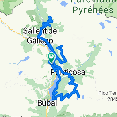
A cycling route starting in Sallent de Gállego, Aragon, Spain.
Overview
About this route
Etappe 5: Formigal (S) – Argeles Gazost (F), afstand 90 km. Met: Col d’Aubisque (1710 m) en Col du Soulor (1474 m). Overnachting in Hotel du Soleil Levant, Avenu des Pyrénées 17, Argelès-Gazost 65400 Frankrijk.
- -:--
- Duration
- 80.5 km
- Distance
- 1,592 m
- Ascent
- 2,702 m
- Descent
- ---
- Avg. speed
- ---
- Avg. speed
Route quality
Waytypes & surfaces along the route
Waytypes
Busy road
74.3 km
(92 %)
Quiet road
2.6 km
(3 %)
Surfaces
Paved
56 km
(70 %)
Unpaved
0.4 km
(<1 %)
Asphalt
56 km
(70 %)
Ground
0.4 km
(<1 %)
Undefined
24.1 km
(30 %)
Continue with Bikemap
Use, edit, or download this cycling route
You would like to ride HPSV E5 8sep or customize it for your own trip? Here is what you can do with this Bikemap route:
Free features
- Save this route as favorite or in collections
- Copy & plan your own version of this route
- Sync your route with Garmin or Wahoo
Premium features
Free trial for 3 days, or one-time payment. More about Bikemap Premium.
- Navigate this route on iOS & Android
- Export a GPX / KML file of this route
- Create your custom printout (try it for free)
- Download this route for offline navigation
Discover more Premium features.
Get Bikemap PremiumFrom our community
Other popular routes starting in Sallent de Gállego
 ESCARRILLA-ASNOS-O FRONDÓN-IBONCIECHO
- Distance
- 72.7 km
- Ascent
- 2,584 m
- Descent
- 2,573 m
- Location
- Sallent de Gállego, Aragon, Spain
 3000 Ibones - Marmotilla
- Distance
- 39 km
- Ascent
- 2,627 m
- Descent
- 2,627 m
- Location
- Sallent de Gállego, Aragon, Spain
 Calle de la Carretera, Sallent de Gállego à Calle del Polígono Ganadero, Sallent de Gállego
- Distance
- 13 km
- Ascent
- 935 m
- Descent
- 933 m
- Location
- Sallent de Gállego, Aragon, Spain
 Formigal - Portalet - Aubisque - Portalet - Sarrios - Formigal
- Distance
- 107.8 km
- Ascent
- 2,882 m
- Descent
- 2,882 m
- Location
- Sallent de Gállego, Aragon, Spain
 2010.07.24. Sallent de Gallego - Puerto Cotefablo - Torla - Ordesa canyon - Fanlo - P... = 105,75 km + ..
- Distance
- 99.6 km
- Ascent
- 1,561 m
- Descent
- 2,199 m
- Location
- Sallent de Gállego, Aragon, Spain
 Escarrilla subida pacino
- Distance
- 44.6 km
- Ascent
- 1,079 m
- Descent
- 1,078 m
- Location
- Sallent de Gállego, Aragon, Spain
 Formigal estación sky-Biescas-Portalet-Formigal estación sky
- Distance
- 71.2 km
- Ascent
- 1,718 m
- Descent
- 1,717 m
- Location
- Sallent de Gállego, Aragon, Spain
 GTP E05 up Sallent de Gallego - Nerin
- Distance
- 76.4 km
- Ascent
- 3,059 m
- Descent
- 3,049 m
- Location
- Sallent de Gállego, Aragon, Spain
Open it in the app