
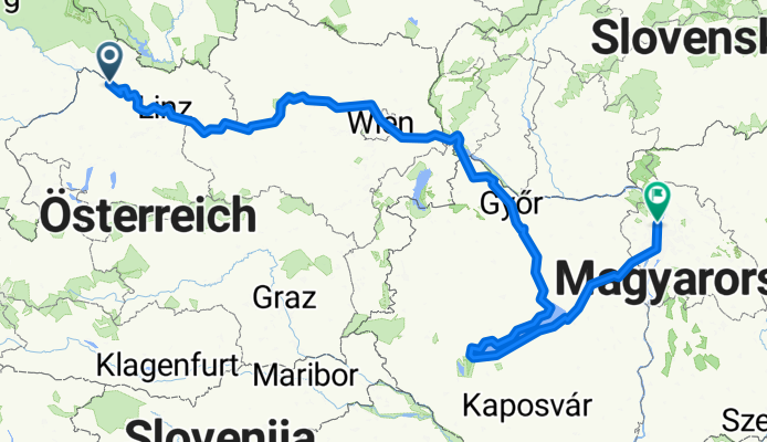
Passau -Plattensee-Budapest 2004
A cycling route starting in Pfarrkirchen im Mühlkreis, Upper Austria, Austria.
Overview
About this route
- -:--
- Duration
- 842.5 km
- Distance
- 420 m
- Ascent
- 628 m
- Descent
- ---
- Avg. speed
- ---
- Avg. speed
Route quality
Waytypes & surfaces along the route
Waytypes
Cycleway
230.8 km
(27 %)
Quiet road
199.7 km
(24 %)
Surfaces
Paved
733.5 km
(87 %)
Unpaved
25.8 km
(3 %)
Asphalt
708.1 km
(84 %)
Paving stones
15.4 km
(2 %)
Route highlights
Points of interest along the route
Point of interest after 415.7 km
Campingplatz mit den vielen Stechmücken und dem Doppeldecker der gesprüht hat. Auf der anderen Staraßenseite gab es ein Thermalschwimmbad
Point of interest after 459.4 km
In Göyr auf dem Festplatz schön Pause gemacht. Nette Leute getroffen.
Point of interest after 479.6 km
Campingplatz unterhakb des Klosters. Geldautomat gefunden !!!!!!!!
Continue with Bikemap
Use, edit, or download this cycling route
You would like to ride Passau -Plattensee-Budapest 2004 or customize it for your own trip? Here is what you can do with this Bikemap route:
Free features
- Save this route as favorite or in collections
- Copy & plan your own version of this route
- Sync your route with Garmin or Wahoo
Premium features
Free trial for 3 days, or one-time payment. More about Bikemap Premium.
- Navigate this route on iOS & Android
- Export a GPX / KML file of this route
- Create your custom printout (try it for free)
- Download this route for offline navigation
Discover more Premium features.
Get Bikemap PremiumFrom our community
Other popular routes starting in Pfarrkirchen im Mühlkreis
 Marsbach- Aschach
- Distance
- 73.6 km
- Ascent
- 533 m
- Descent
- 320 m
- Location
- Pfarrkirchen im Mühlkreis, Upper Austria, Austria
 Donauradweg: Passau-Budapest
- Distance
- 534.3 km
- Ascent
- 510 m
- Descent
- 649 m
- Location
- Pfarrkirchen im Mühlkreis, Upper Austria, Austria
 12.Engelhartszell-Hofkirchen
- Distance
- 60.6 km
- Ascent
- 586 m
- Descent
- 574 m
- Location
- Pfarrkirchen im Mühlkreis, Upper Austria, Austria
 🚴♀️E*Bike🇦🇹 Hakendorf-Natternbach
- Distance
- 31.3 km
- Ascent
- 387 m
- Descent
- 386 m
- Location
- Pfarrkirchen im Mühlkreis, Upper Austria, Austria
 Niederranna - Passau u. zurück rechts
- Distance
- 67.2 km
- Ascent
- 372 m
- Descent
- 411 m
- Location
- Pfarrkirchen im Mühlkreis, Upper Austria, Austria
 🚴♀️E*Bike🇦🇹Kaufmann-Runde
- Distance
- 30.6 km
- Ascent
- 369 m
- Descent
- 365 m
- Location
- Pfarrkirchen im Mühlkreis, Upper Austria, Austria
 Niederranna-Ottensheim (Donauradweg)
- Distance
- 56.1 km
- Ascent
- 243 m
- Descent
- 250 m
- Location
- Pfarrkirchen im Mühlkreis, Upper Austria, Austria
 Donau-Radweg Etappe 2.1
- Distance
- 21.4 km
- Ascent
- 250 m
- Descent
- 283 m
- Location
- Pfarrkirchen im Mühlkreis, Upper Austria, Austria
Open it in the app