
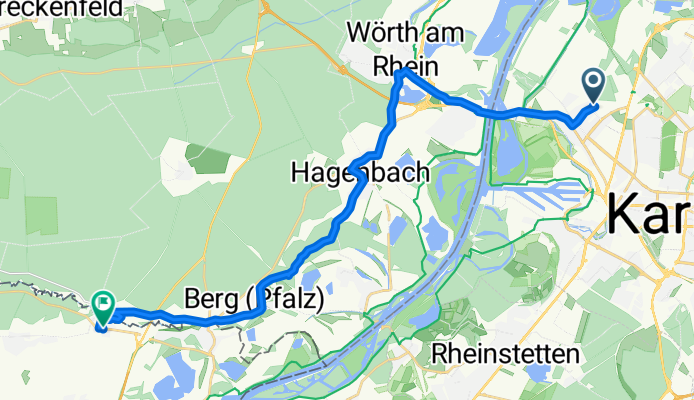
Ausfahrt von Karlsruhe nach Scheibenhardt
A cycling route starting in Karlsruhe, Baden-Württemberg, Germany.
Overview
About this route
- 1 h 48 min
- Duration
- 24.1 km
- Distance
- 74 m
- Ascent
- 59 m
- Descent
- 13.4 km/h
- Avg. speed
- ---
- Avg. speed

Route quality
Waytypes & surfaces along the route
Waytypes
Path
8.4 km
(35 %)
Quiet road
8.3 km
(34 %)
Surfaces
Paved
21 km
(87 %)
Unpaved
0.8 km
(3 %)
Asphalt
17.7 km
(74 %)
Paved (undefined)
1.7 km
(7 %)
Continue with Bikemap
Use, edit, or download this cycling route
You would like to ride Ausfahrt von Karlsruhe nach Scheibenhardt or customize it for your own trip? Here is what you can do with this Bikemap route:
Free features
- Save this route as favorite or in collections
- Copy & plan your own version of this route
- Sync your route with Garmin or Wahoo
Premium features
Free trial for 3 days, or one-time payment. More about Bikemap Premium.
- Navigate this route on iOS & Android
- Export a GPX / KML file of this route
- Create your custom printout (try it for free)
- Download this route for offline navigation
Discover more Premium features.
Get Bikemap PremiumFrom our community
Other popular routes starting in Karlsruhe
 KA -> Bad Herrenalb und über Bernbach zurück
- Distance
- 62.1 km
- Ascent
- 487 m
- Descent
- 487 m
- Location
- Karlsruhe, Baden-Württemberg, Germany
 n bisschen Schwarzwald
- Distance
- 55.4 km
- Ascent
- 670 m
- Descent
- 656 m
- Location
- Karlsruhe, Baden-Württemberg, Germany
 Durlach-Pfinztal Runde
- Distance
- 39.3 km
- Ascent
- 413 m
- Descent
- 406 m
- Location
- Karlsruhe, Baden-Württemberg, Germany
 Karlsruhe - Turmberg - Stupferich - Mutschelbach - Langensteinbach - Ittersbach - Schöllbronn - Ettlingen - Karlsruhe
- Distance
- 59 km
- Ascent
- 514 m
- Descent
- 515 m
- Location
- Karlsruhe, Baden-Württemberg, Germany
 KA: Abendlicher Rundkurs +/- 1h 15min
- Distance
- 30.5 km
- Ascent
- 51 m
- Descent
- 49 m
- Location
- Karlsruhe, Baden-Württemberg, Germany
 Kleine Feierabendrunde
- Distance
- 24.3 km
- Ascent
- 99 m
- Descent
- 100 m
- Location
- Karlsruhe, Baden-Württemberg, Germany
 KA - Durlach - Wattkopf - Muschelbach - Thomashof - KA
- Distance
- 48.9 km
- Ascent
- 656 m
- Descent
- 654 m
- Location
- Karlsruhe, Baden-Württemberg, Germany
 Kreuzung Adenauerring / Grabener Allee zur Insel Rott
- Distance
- 16.5 km
- Ascent
- 17 m
- Descent
- 37 m
- Location
- Karlsruhe, Baden-Württemberg, Germany
Open it in the app