

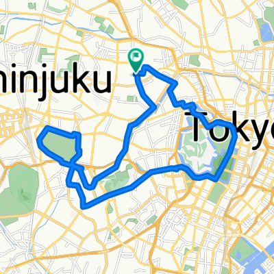
JR御徒町駅 to JR有楽町
A cycling route starting in Tokyo, Tokyo, Japan.
Overview
About this route
- -:--
- Duration
- 6.7 km
- Distance
- 90 m
- Ascent
- 66 m
- Descent
- ---
- Avg. speed
- ---
- Max. altitude

Route highlights
Points of interest along the route
Point of interest after 0.1 km
この辺りが宝飾加工店、成美。母の形見の指輪を加工してもらう。

Point of interest after 0.3 km
上野、御徒町駅からちょっと離れたところであるが様子は全く異なる商店街。

Point of interest after 0.3 km
「2k540 AKI-OKA ARTISAN」で嫁の久留米絣パンツを買い求める
Point of interest after 0.6 km
ソニーの修理承り店。VTRハンディーカメラの基本修理代が2万円と聴く。新品を書くべきか?
Point of interest after 0.8 km
ここら辺り昔の古い時代の面影を残す。
Point of interest after 1.2 km
かなりディープな店舗による。メーカー製の商品を安価で購入。
Continue with Bikemap
Use, edit, or download this cycling route
You would like to ride JR御徒町駅 to JR有楽町 or customize it for your own trip? Here is what you can do with this Bikemap route:
Free features
- Save this route as favorite or in collections
- Copy & plan your own version of this route
- Sync your route with Garmin or Wahoo
Premium features
Free trial for 3 days, or one-time payment. More about Bikemap Premium.
- Navigate this route on iOS & Android
- Export a GPX / KML file of this route
- Create your custom printout (try it for free)
- Download this route for offline navigation
Discover more Premium features.
Get Bikemap PremiumFrom our community
Other popular routes starting in Tokyo
 Shioiri Park-Skytree-Taito-Ku
- Distance
- 16.6 km
- Ascent
- 820 m
- Descent
- 816 m
- Location
- Tokyo, Tokyo, Japan
 20-12, Nakaochiai 4-Chōme, Shinjuku to Shinko 1-Chōme, Naka, Yokohama
- Distance
- 43.8 km
- Ascent
- 423 m
- Descent
- 455 m
- Location
- Tokyo, Tokyo, Japan
 Japedal Stage 1 - Tōkyō to Osaka (Tōkaidō)
- Distance
- 688.4 km
- Ascent
- 6,371 m
- Descent
- 6,372 m
- Location
- Tokyo, Tokyo, Japan
 JUL-18-10-ARAKAWA
- Distance
- 90.1 km
- Ascent
- 148 m
- Descent
- 148 m
- Location
- Tokyo, Tokyo, Japan
 20200104_Shinozaki Park-Kasai Seaside Park
- Distance
- 38.8 km
- Ascent
- 672 m
- Descent
- 671 m
- Location
- Tokyo, Tokyo, Japan
 JR池袋駅 to JR有楽町駅(秋葉原経由)
- Distance
- 15.6 km
- Ascent
- 101 m
- Descent
- 134 m
- Location
- Tokyo, Tokyo, Japan
 160313_tour_de_tsukuruba#1
- Distance
- 134.9 km
- Ascent
- 177 m
- Descent
- 185 m
- Location
- Tokyo, Tokyo, Japan
 Yaraicho, Shinjuku à Yaraicho, Shinjuku
- Distance
- 19.7 km
- Ascent
- 148 m
- Descent
- 151 m
- Location
- Tokyo, Tokyo, Japan
Open it in the app