

B2B55116>55113viaMissiBlvd/Como/Hamline
A cycling route starting in Mendota Heights, Minnesota, United States of America.
Overview
About this route
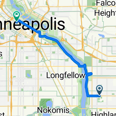
Take St. Paul Avenue to Cleveland. North on Cleveland to Highland Pkwy. Left on Highland Pkwy. to Mississippi River Blvd. Turn right and go north on Mississippi River Blvd. Just after passing under the Marshall/Lake St. bridge turn right to Pelham Blvd. Nice hill up along side Town & Country golf course. Follow Pelham Blvd. to Myrtle Av. Turn right to Raymond Av. Follow Raymond until you get to Como Avenue. Turn right and follow Como past the Fair ground until you get to Hamline Avenue. Turn left at Hamline Avenue. Follow Hamline Avenue north until Lydia. Turn left at Lydia. Lydia will take you directly to the entrance of Northwestern College.
- -:--
- Duration
- 20.1 km
- Distance
- 159 m
- Ascent
- 120 m
- Descent
- ---
- Avg. speed
- 288 m
- Avg. speed
Route quality
Waytypes & surfaces along the route
Waytypes
Road
7.9 km
(40 %)
Cycleway
6.1 km
(30 %)
Surfaces
Paved
12.7 km
(63 %)
Asphalt
11.1 km
(55 %)
Paved (undefined)
0.9 km
(5 %)
Continue with Bikemap
Use, edit, or download this cycling route
You would like to ride B2B55116>55113viaMissiBlvd/Como/Hamline or customize it for your own trip? Here is what you can do with this Bikemap route:
Free features
- Save this route as favorite or in collections
- Copy & plan your own version of this route
- Sync your route with Garmin or Wahoo
Premium features
Free trial for 3 days, or one-time payment. More about Bikemap Premium.
- Navigate this route on iOS & Android
- Export a GPX / KML file of this route
- Create your custom printout (try it for free)
- Download this route for offline navigation
Discover more Premium features.
Get Bikemap PremiumFrom our community
Other popular routes starting in Mendota Heights
 B2B 55116 > 55106 via Summit Ave, Kellogg Blvd E
- Distance
- 14.3 km
- Ascent
- 40 m
- Descent
- 63 m
- Location
- Mendota Heights, Minnesota, United States of America
 Mendota to Calhoun
- Distance
- 22 km
- Ascent
- 171 m
- Descent
- 132 m
- Location
- Mendota Heights, Minnesota, United States of America
 River Loop
- Distance
- 15.5 km
- Ascent
- 99 m
- Descent
- 98 m
- Location
- Mendota Heights, Minnesota, United States of America
 Big Rivers, Pilot Knob, Acadia, Valley Park, ...
- Distance
- 13.3 km
- Ascent
- 206 m
- Descent
- 206 m
- Location
- Mendota Heights, Minnesota, United States of America
 Mendota Heights-South St.Paul
- Distance
- 35.7 km
- Ascent
- 218 m
- Descent
- 218 m
- Location
- Mendota Heights, Minnesota, United States of America
 B2B00914 55116>55435 via Mend Brg, 494 bike brg, 73rd
- Distance
- 22.6 km
- Ascent
- 141 m
- Descent
- 132 m
- Location
- Mendota Heights, Minnesota, United States of America
 Fort Snelling Loop
- Distance
- 33.8 km
- Ascent
- 162 m
- Descent
- 164 m
- Location
- Mendota Heights, Minnesota, United States of America
 B2B00191 55115>55401viaRandolph/MissBlvd/LkStBridge/WRiverPkwy/WashAv
- Distance
- 11.6 km
- Ascent
- 97 m
- Descent
- 109 m
- Location
- Mendota Heights, Minnesota, United States of America
Open it in the app