

Üfingen-Lengede-Alvesse
A cycling route starting in Braunschweig, Lower Saxony, Germany.
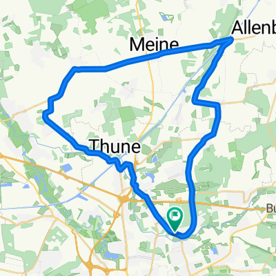
Overview
About this route
Ausfahrt vom 30.12.16, 5°, leichter SW- Wind, trocken, 4:04 reine Fahrzeit.
Strecke von 58 Km und ca. 370 Hm führte von der Roten Wiese in Richtung Südsee und weiter über Trailanteile bei Geitelde zum Güterbahnhof Beddingen. Von dort ging es über Feldweg zu den ehemaligen Erzgruben bei Lengede und ins Naturschutzgebiet Lengede mit dem Seilbahnberg mit 62 m Höhe. Der Rückweg verlief über Feldweg und ein kleiner Anteil Landstrasse zur Schleuse Üfingen. Über den Steinberg 101m ü.N.N. ging es zurück zum Startpunkt. Die Strecke ist gut geeignet als Grundlagentraining und bietet dabei z.T. schöne Trailabschnitte und auch paar heftige Rampen und Treppenpassagen für Techniker. Bei dieser Ausfahrt lernt man mal den Westen von Braunschweig kennen.
- -:--
- Duration
- 57.8 km
- Distance
- 121 m
- Ascent
- 122 m
- Descent
- ---
- Avg. speed
- ---
- Avg. speed

Route highlights
Points of interest along the route
Point of interest after 5.2 km
Trailabschnitt durch Geitelder Horst
Point of interest after 9.5 km
Beddinger Rangierbahnhof
Point of interest after 17 km
Wiesenpfad
Point of interest after 20.6 km
schöner Singletrail
Point of interest after 21.6 km
Singletrail
Point of interest after 24.9 km
Singletrail direkt an der Fuhse
Point of interest after 26 km
schöner Singletrail mit Absatz
Point of interest after 30.1 km
Trailabschnitte
Point of interest after 31.7 km
Trails direkt am Ufer
Point of interest after 33.4 km
Rutsche und Aufstieg zu Fuß mit Rad
Point of interest after 33.5 km
Aussichtpunkt mit Rundumblick
Point of interest after 33.7 km
Treppenaufstieg und Abfahrtsrampe
Point of interest after 51.9 km
Trailabschnitt Geitelder Horst
Continue with Bikemap
Use, edit, or download this cycling route
You would like to ride Üfingen-Lengede-Alvesse or customize it for your own trip? Here is what you can do with this Bikemap route:
Free features
- Save this route as favorite or in collections
- Copy & plan your own version of this route
- Sync your route with Garmin or Wahoo
Premium features
Free trial for 3 days, or one-time payment. More about Bikemap Premium.
- Navigate this route on iOS & Android
- Export a GPX / KML file of this route
- Create your custom printout (try it for free)
- Download this route for offline navigation
Discover more Premium features.
Get Bikemap PremiumFrom our community
Other popular routes starting in Braunschweig
 BS-GS-Clausthal-Oker-Schladen-Wf-BS
- Distance
- 148.8 km
- Ascent
- 983 m
- Descent
- 979 m
- Location
- Braunschweig, Lower Saxony, Germany
 Cyclions-Harztour
- Distance
- 150.9 km
- Ascent
- 1,113 m
- Descent
- 1,099 m
- Location
- Braunschweig, Lower Saxony, Germany
 Braunschweig-Fallersleben
- Distance
- 27 km
- Ascent
- 73 m
- Descent
- 73 m
- Location
- Braunschweig, Lower Saxony, Germany
 Rund um Braunschweig
- Distance
- 42.1 km
- Ascent
- 122 m
- Descent
- 127 m
- Location
- Braunschweig, Lower Saxony, Germany
 BS-Nord (sehr kurz)
- Distance
- 34.9 km
- Ascent
- 62 m
- Descent
- 49 m
- Location
- Braunschweig, Lower Saxony, Germany
 Nördliche Runde
- Distance
- 47.1 km
- Ascent
- 82 m
- Descent
- 82 m
- Location
- Braunschweig, Lower Saxony, Germany
 braunschweigs Kleine Nordrunde
- Distance
- 44.7 km
- Ascent
- 122 m
- Descent
- 120 m
- Location
- Braunschweig, Lower Saxony, Germany
 Mühlentour
- Distance
- 70.5 km
- Ascent
- 343 m
- Descent
- 334 m
- Location
- Braunschweig, Lower Saxony, Germany
Open it in the app